


CBSE Class IX Term I Geography SQP (Sample Question Paper) 2021-22
CBSE Class IX Term I Geography Sample Question Paper 2021-22 (3 sets). How to revise Geography in less than 10 Days. This is a question which must be cropping up in every student of class 9. But, don’t worry. In this article you will get three sets of class IX term I Geography SQP. Solve all the three sets and you will get an idea about the pattern of question paper. Set I is of average level, Set II is of Moderate level and Set III includes Difficult level. You already know that CBSE class IX term I Social Science SQP will be based on the new rationalized syllabus. Here, only Geography questions are given. What are you waiting for? Start solving all three sets of CBSE Class IX Term I Geography Sample Question Paper 2021-22.
Marking scheme is also provided with each set of question paper. If you are still confused about the new syllabus,, click on the link givenhttp://cbseacademic.nic.in/term-wise-curriculum_2022.html
CONTENT:
1. CLASS IX TERM I SOCIAL SCIENCE (GEOGRAPHY) SAMPLE QUESTION PAPER 2021-22 SET I AVERAGE LEVEL WITH MARKING SCHEME.
2. CLASS IX TERM I SOCIAL SCIENCE (GEOGRAPHY) SAMPLE QUESTION PAPER 2021-22
SET II MODERATE LEVEL WITH MARKING SCHEME.
3. CLASS IX TERM I SOCIAL SCIENCE (GEOGRAPHY) SAMPLE QUESTION PAPER 2021-22
SET III DIFFICULT LEVEL WITH MARKING SCHEME.
CBSE Class IX Term I Geography SQP (Sample Question Paper) 2021-22
SET- I (AVERAGE LEVEL)
SOCIAL SCIENCE (GEOGRAPHY) SAMPLE QUESTION PAPER 2021-22 TERM – I
CLASS – IX
SOCIAL SCIENCE – CODE (087)
TIME: 90 MINUTES MM: 40
—————————————————————————————————————————————————————————-
General Instructions:
1. The Question Paper contains four sections.
2. Section A has 24 questions. Attempt any 20 questions.
3. Section B has 22 questions. Attempt any 18 questions.
4. Section C has 12 questions (Case based). Attempt any 10 questions.
5. Section D contains 2 Map based questions. Attempt both the questions.
6. All questions carry equal marks.
7. There is no negative marking.
SECTION – A
(Attempt any 20 out of 24 questions)
(Note: There will be 5 MCQ’s from Geography)
1 The latitudinal extent of India is
A. 8°4’N and 37°6’S
B. 8°4’N and 37°6’N
C. 68°7’E and 97°25’W.
D. 68°7’E and 97°25’E.
2. The southernmost point of the Indian Union ‘Indira Point ’ got submerged under the sea water in ______________ during the Tsunami.
A. 1998
B. 2002
C. 2004
D. 2006
3. The Standard Meridian of India (82°30’E) passes through ________________ in Uttar Pradesh.
A. Mirzapur
B. Lucknow
C. Dehradun
D. Ahmedabad.
4. West Bengal shares its borders with
A. Nepal and Bangladesh
B. Bangladesh and Bhutan
C. Bhutan and Myanmar
D. Nepal, Bangladesh and Bhutan
5. What separates India with Sri Lanka.
A. Indian Ocean
B. Gulf of Manner
C. Suez Canal.
D. Indira Point.
SECTION – B
(Attempt any 18 out of 22 questions)
6 Assertion : Before 1947, there were two types of states in India — the provinces and the Princely states.
Reason: Provinces were ruled directly by British officials,
Codes
(A) Both A and R are true and R is the correct explanation of A
(B) Both A and R are true, but R is not the correct explanation of A
(C) Both A and R are false
(D) A is false, but R is true
7. Assertion: Geologically, the Peninsular Plateau constitutes one of the ancient landmasses on the earth’s surface.
Reason: The plateau is composed of sedimentary rocks.
Codes
(A) Both A and R are true and R is the correct explanation of A
(B) Both A and R are true, but R is not the correct explanation of A
(C) Both A and R are false
(D) A is false, but R is true
SECTION – C
(Attempt any 10 out of 12 questions)
The range lying to the south of the Himadri forms the most rugged mountain system. The ranges are mainly composed of highly compressed and altered rocks. The
altitude varies between 3,700 and 4,500 meters and the average width is of 50 Km. While the Pir Panjal range forms the longest and the most important range, the Dhaula Dhar and the Mahabharat ranges are also prominent ones. This range consists of the famous valley of Kashmir, the Kangra and Kullu Valley in Himachal Pradesh. This region is well-known for its hill stations.
8. Which range has been described in the paragraph.
A. Himadri
B. Himachal
C. Shiwalik
D. Karakoram.
9. The range described is famous for its hill stations. Which hill stations are located on this range?
A. Shimla, Anai Mudi, Mount Abu.
B. Mussoorie, Ranikhet, Nainital.
C. Nainital, Darjeeling, Mahendragiri
D. Shimla, Dehradun, Doda Beta.
10. Name the longest and the most prominent range mentioned in the paragraph.
A. Pir Panjal
B. Dhaula Dhar
C. Mahabharat range
D. Kullu valley.
11. The average width of the range mentioned in the paragraph is _____________?
A. 30 KM
B. 40 KM
C. 50 KM
D. 60 KM
12. Why do you think this range is composed of highly compressed and altered rocks?
A. Because Himalayas were formed in the sea called Tethys.
B. Because this range was formed by volcanic eruption.
C. Because this range is compressed between two ranges.
D. Because this is the oldest range of Himalayas.
13. Name the range which lie to the south of the range mentioned in the paragraph.
A. Himadri
B. Himachal
C. Shiwalik
D. None of the above.
Section D
(Attempt both the Map based questions)
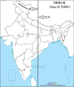
14. On the political map of India, ‘A’ is marked as an Indian State. Identify it from the following options.
 2021-22")
Class 9 Term I Geography SQP (Sample Question Paper) 2021-22
A. Tripura
B. Nagaland
C. Meghalaya
D. Mizoram
15. On the same map, ‘B’ is also marked as a Mountain range. Identify the correct option from the following:
A. Vindhya
B. Satpura
C, Aravalli
D. Shiwalik
CBSE Class IX Term I Geography SQP (Sample Question Paper) 2021-22
ANSWER KEY SET- I (AVERAGE LEVEL)
SECTION – A
- B. 8°4’N and 37°6’N 2. C. 2004 3. A. Mirzapur 4. D. Nepal, Bangladesh and Bhutan 5. B. Gulf of Manner
SECTION – B
6. (A) Both A and R are true and R is the correct explanation of A 7. (B) Both A and R are true, but R is not the correct explanation of A
SECTION – C
8. B. Himachal 9. B. Mussoorie, Ranikhet, Nainital. 10. A. Pir Panjal 11. C. 50 KM 12. C. Because this range is compressed between two ranges 13. C. Shiwalik
Section D
14. D. Mizoram 15. C, Aravalli
You may be interested in
CBSE Class IX Term I Geography SQP (Sample Question Paper) 2021-22
SET- II (MODERATE LEVEL)
SOCIAL SCIENCE (GEOGRAPHY) SAMPLE QUESTION PAPER 2021-22 TERM – I
CLASS – IX
SOCIAL SCIENCE – CODE (087)
TIME: 90 MINUTES MM: 40
——————————————————————————————————————————————————————————-
General Instructions:
1. The Question Paper contains four sections.
2. Section A has 24 questions. Attempt any 20 questions.
3. Section B has 22 questions. Attempt any 18 questions.
4. Section C has 12 questions (Case based). Attempt any 10 questions.
5. Section D contains 2 Map based questions. Attempt both the questions.
6. All questions carry equal marks.
7. There is no negative marking.
SECTION – A
Q1. Which Indian state does not touch the borders of Pakistan?
A. Punjab
B. Haryana
C. Gujarat
D. Rajasthan
Q2. India’s east-west extent is _______________
A. 2933KM
B. 3214 KM
C. 2133 KM
D. 3421 KM
Q3. The smallest and the largest states of India are ___________ and ___________________.
A. Madhya Pradesh and Sikkim
B. Rajasthan and Goa
C. Maharashtra and Tripura
D. Tamil Nadu and Uttarakhand
Q4. The Tropic of Cancer passes through which two North Eastern states of India.
A. Tripura and Nagaland.
B. Nagaland and Mizoram
C. Mizoram and Meghalaya
D. Meghalaya and Tripura.
Q5. If the local time at Ahmedabad located at (72.5 degree Longitude) is 8:30 a.m. What will be the time at IST located at 82° 30′ E Longitude.
A. 8:30 a.m.
B. 9:10 a.m.
C. 7:50 a.m.
D. 8: 47 a.m.
SECTION – B
(Attempt any 18 out of 22 questions)
Q6. Assertion: The Himalayas have been divided on the basis of regions from west to east. These divisions have been demarcated by river valleys.
Reason: The part of the Himalayas lying between Sutlej and Kali rivers is known as Kumaon Himalayas.
Codes
(A) Both A and R are true and R is the correct explanation of A
(B) Both A and R are true, but R is not the correct explanation of A
(C) Both A and R are false
(D) A is false, but R is true
Q7. Laccadive, Minicoy and Amin dive were the names of _________ ?
A. Lakshadweep Islands
B. Andaman Islands
C. Nicobar Islands
D. Majuli Islands.
SECTION – C
(Attempt any 10 out of 12 questions)
The Peninsular plateau is a tableland composed of the old crystalline, igneous and metamorphic rocks. It was formed due to the breaking and drifting of the Gondwanan land and thus, making it a part of the oldest landmass. The plateau has broad and shallow valleys and rounded hills. This plateau consists of two broad divisions, namely, the Central Highlands and the Deccan Plateau. The part of the Peninsular plateau lying to the north of the Narmada river, covering a major area of the Malwa plateau, is known as the Central Highlands.
Q8. Peninsular plateau was the part of _____________________ .
A. Angara land
B. Gondwanaland
C. Malwa Plateau
D. Central Highlands.
Q9. The Peninsular Plateau was formed due to ___________________-
A. Accumulation of silts in the sea.
B. Depositional activity by the rivers.
C. due to the breaking and drifting of the Gondwanan land
D. None of the above
Q10. What is Peninsular Plateau composed of ?
A. Igneous and sedimentary rocks.
B. Sedimentary and Metamorphic rocks.
C. Metamorphic and Igneous rocks.
D. Igneous rocks.
Q11. What is the part of the Peninsular plateau lying to the South of Narmada river called?
A. Gondwanaland
B. Central Highlands
C. Malwa Plateau
D. Deccan Plateau.
Q12. Two broad divisions of the Peninsular Plateau are __________ and ____________.
A. Central Highlands and Deccan Plateau
B. Malwa Plateau and Central highlands.
C. Gondwanaland and Central highlands.
D. Old landmass and New landmass.
Q13. Why do you think the plateau has broad and rounded hills?
A. Because the plateau is not very high.
B. Because of weathering and erosional activity.
C. Because it was formed by volcanic activity.
D. Because it was the part of Gondwanaland.
Section D
(Attempt both the Map based questions)
14. On the political map of India, ‘A’ is marked as coastal plain. Identify it from the following options.
 2021-22")
Class 9 Term I Geography SQP (Map Based Sample Questions) 2021-22
A. Malabar
B. Northern Circars
C. Konkan
D. Coromandal
15. On the same map, ‘B’ is also marked as an Indian State. Identify the correct option from the following:
A. Bihar
B. Jharkhand
C, Uttar Pradesh
D. Orissa
CBSE Class IX Term I Geography SQP (Sample Question Paper) 2021-22
ANSWER KEY SET- I (AVERAGE LEVEL)
SECTION – A
1 B. Haryana 2. A. 2933KM 3. B. Rajasthan and Goa 4. D. Meghalaya and Tripura. 5. B. 9:10 a.m.
SECTION – B
6. (A) Both A and R are true and R is the correct explanation of A 7. A. Lakshadweep Islands
SECTION – C
8. B. Gondwanaland 9. 8. C. due to the breaking and drifting of the Gondwanan land 10. A. Igneous and sedimentary rocks. 11. D. Deccan Plateau.
12. A. Central Highlands and Deccan Plateau 13. B. Because of weathering and erosional activity.
Section – D
14. C. Konkan 15. B. Jharkhand
_________________________________________________________________________________________________________________________________________________________________________
CBSE Class IX Term I Geography SQP (Sample Question Paper) 2021-22
SET- III (Difficult Level)
SOCIAL SCIENCE (GEOGRAPHY) SAMPLE QUESTION PAPER 2021-22 TERM – I
CLASS – IX
SOCIAL SCIENCE – CODE (087)
TIME: 90 MINUTES MM: 40
——————————————————————————————————————————————————————————–
General Instructions:
1. The Question Paper contains four sections.
2. Section A has 24 questions. Attempt any 20 questions.
3. Section B has 22 questions. Attempt any 18 questions.
4. Section C has 12 questions (Case based). Attempt any 10 questions.
5. Section D contains 2 Map based questions. Attempt both the questions.
6. All questions carry equal marks.
7. There is no negative marking.
___________________________________________________________________________________________________________________________________________________________________________
SECTION – A
(Attempt any 20 out of 24 questions)
1. What percentage of the total Geographical area of the world India accounts for?
A. 2.4
B. 2.8
C. 3.28
D. 4.2
2. Eastern most Longitude of India is located in which State / Union Territory?
A. Mirzapur in Uttar Pradesh
B. Gujarat
C. Indira Point in Andaman & Nicobar islands.
D. Arunachal Pradesh.
3. What is total length of the coastline of the Indian mainland including Andaman and Nicobar and Lakshadweep ?
A. 5716.6 KM
B. 7516.6 KM
C. 15200 KM
D. 3214 KM
4. By how many kilometers is the North-South extent of India larger than its East-West extent?
A. 201
B. 211
C. 221
D. 231
5. Identify the country which is bigger than India in size.
A. Brazil
B. Argentina
C. Thailand
D. Mexico
SECTION – B
(Attempt any 18 out of 22 Questions)
6. Assertion: Himachal is the most continuous range consisting of the loftiest peaks with an average height of 6,000 metres.
Reason: Himachal range also contains all prominent Himalayan peaks.
Codes
(A) Both A and R are true and R is the correct explanation of A
(B) Both A and R are true, but R is not the correct explanation of A
(C) Both A and R are false
(D) A is false, but R is true
7. Match Column I with column II and select the correct option.
COLUMN A | COLUMN B |
a. Himalayas lying between Satluj and Kali rivers | i. Kumaon Himalayas |
b. Himalayas lying between Indus and Satluj | ii. Assam Himalayas |
c. Himalayas lying between the Kali and Teesta rivers | iii. Punjab Himalayas |
d. Himalayas lying between Teesta and Dihang rivers | iv. Nepal Himalayas |
Codes
A. a-ii, b- iv, c-i, d-iii.
B. a-i, b-iii, c- iv, d-ii.
C. a-i, b- iii, c- ii, d-iv.
D. a-iv, b-ii, c-i, d-iii.
SECTION – C
(Attempt any 5 out of 6 questions in each of the Case based questions)
The Western Ghats and the Eastern Ghats mark the western and the eastern edges of the Deccan Plateau respectively. Western Ghats lie parallel to the western coast. They are continuous and can be crossed through passes only.The Western Ghats are higher than the Eastern Ghats. Their average elevation is 900– 1600 metres as against 600 metres of the Eastern Ghats. The Eastern Ghats are discontinuous and irregular. The height of the Western Ghats progressively increases from north to south. Shevroy Hills and the Javadi Hills are located to the southeast of the Eastern Ghats.
8. Which is the highest peak of Western Ghats?
A. Mt. Everest.
B. Mt. Abu
C. Anai Mudi
D. Udagamandalam
9. Why are the Eastern Ghats discontinuous and irregular?
A. Because western ghats are higher than eastern ghats.
B. Because the flow of rivers bissect the eastern ghats.
C. Because there are number of passes.
D. Because they are made of igneous and metamorphic rocks.
10. Western Ghats lie parallel to the western coast. Identify the coastal plains that lie to the west of Western Ghats.
A. Konkan, Kannad, Coromandal
B. Northern Circars, Coromandal and Malabar.
C. Konkan, Kannad and Malabar.
D. Coromandal, Konkan and Malabar.
11. The height of the western Ghats decreases from
A. South to North.
B. North to South.
C. East to West
D. West to East.
12. Identify a hill station located in Deccan plateau.
A. Dehradun
B. Vishakhapattnam
C. Mt. Abu
D. Kodaikanal
13. Eastern Ghats are located to the ______________ of Shevroy Hills and the Javadi Hills.
A. East
B. West
C. North east
D. North West.
Section D
(Attempt both the Map based questions)
14. On the political map of India, ‘A’ is marked as Indian Standard Time (IST). Identify the correct Longitude from the following options.
A. 82° 30′ E
B. 82° 30′ W
C. 82° 30′ N
D. 82° 30′ S
15. On the same map, ‘B’ is also marked as a major Mountain range. Identify the correct option from the following:
A. Himadri Range
B. Zaskar Range
C, Aravalli Range
D. Karakoram Range
____________________________________________________________________________________________________________________________________________________________________________
CBSE Class IX Term I Geography SQP (Sample Question Paper) 2021-22
ANSWER KEY (MARKING SCHEME)
Set – III (Difficult Level)
SECTION – A
1. A. 2.4, 2. D. Arunachal Pradesh 3. B. 7516.6 KM 4. C. 221 5. A. Brazil
SECTION – B
6. (C) Both A and R are false 7. B. a-i, b-iii, c- iv, d-ii.
SECTION – C
8. C. Anai Mudi 9. B. Because the flow of rivers bisect the eastern Ghats. 10. C. Konkan, Kannad and Malabar. 11. A. South to North. 12. D. Kodaikanal 13. D. North West.
SECTION – D
14. A. 82° 30′ E 15. D. Karakoram Range
CBSE Class IX Term I Geography SQP (Sample Question Paper) 2021-22
Conclusion:
Hope, you all must have enjoyed solving CBSE Class IX Term I Geography SQP (Sample Question Paper) 2021-22. By solving all the three sets, you can check your preparation. It will also help you in your revision of Geography portion in less than 10 days. CBSE Class 9 Term I Geography SQP (Sample Question Paper) 2021-22 is designed as per the new curriculum. Which question did you find the most difficult one? Did you face any problem in understanding the questions? Pl. mention your comments in the comment box given below after solving CBSE Class 9 Term I Geography SQP (Sample Question Paper) 2021-22. For better results you may also try CBSE Class IX Geography Term -I MCQ’s Full Syllabus 2021-22 and CLASS IX TERM I MAP WORK FROM GEOGRAPHY SOLVED AS PER THE LATEST SYLLABUS
Best of luck for your exams.
0 Comments