


Class IX Geography Term-I MCQ’s Full Syllabus Practice Paper
Class IX Geography Term-1 MCQ’s at a glance for practice. This year, CBSE has revised the Class IX Geography Term-I and Term-II (Social Science) Syllabus for the current academic session 2020-2021. Board has reduced the Social Science syllabus by 30%. Every student of class IX must go through the latest syllabus to know the prescribed topics and paper pattern that will help them prepare for their upcoming CBSE Terminal Exam 2021 in a better manner. For the convenience of all, case study, Assertion and reason, Fill in the blanks and MCQ’s based questions of class IX Geography Term-I full syllabus is provided here for practice. For TERM II 30 Most Difficult Term II Climate MCQ’s For Class IX Students is also ready for practice.
Why to lose 2 marks in map when you can easily score full marks.
Check out CLASS IX TERM I MAP WORK FROM GEOGRAPHY SOLVED AS PER THE LATEST SYLLABUS
Class IX Geography Term-I MCQ’s Full Syllabus Practice Paper
Chapter 1: India – Size and Location
Q1. Raghu lives in Bhopal. He has gone to play Badminton Nationals at Chennai. From Chennai he will travel in which direction to return back to Bhopal.
A. North.
B. North East
C. North West.
D. South East.
Q2. Which Indian state does not touch the borders of Pakistan?
A. Punjab
B. Haryana
C. Rajasthan
D. Gujarat.
Q3. By how many kilometers is India’s North South extent longer than its East-West extent?
A. 147 KM
B. 193 KM
C. 221 KM
D. 313 KM
Q4. Which place is located at 8°4’N latitude?
A. Cape Comorin
B. Cape of Good Hope.
C. Indira Point
D. Allahabad.
Q5. If the Prime Minister of India is addressing the nation from Aizawl, he is in which state?
A. Mizoram
B. Meghalaya
C. Manipur
D. Arunachal Pradesh.
Q6. Suez canal has reduced the distance of India with which country or continent?
A. India and Africa.
B. India and Europe
C. India and Sri Lanka.
D. India and Australia.
Q7. Identify the country which is bigger than India in size.
A. Thailand
B. Mexico
C. Argentina
D. Brazil
Q8. From which place the Maldives islands will be nearest?
A. Tamil Nadu
B. Sri Lanka
C. Andaman and Nicobar islands.
D. Lakshadweep
Q9. Which one of the following is not a Union Territory of India?
A. Delhi
B. Goa
C. Laddakh
D. Chandigarh.
Q10. A friend of yours visit a place during summer vacation. He describes that the place he visited is known for corals. Which place do you think he must have visited ?
A. Andaman and Nicobar Islands.
B. Lakshadweep
C. Daman and Diu
D. Chilika
Q11. Before 1947, there were two types of states – the provinces and the princely states. The Provinces were ruled directly by
A. British officials.
B. Local Hereditary rulers.
C. Chief Ministers.
D. None of the above.
Q12. Which state do not have an International border or lie on the coast?
A. Uttarakhand
B. Jharkhand
C. Karnataka
D. Assam
Q13. Which union territory lies on the eastern coast of India?
A. Dadra and Nagar Haveli.
B. Andaman and Nicobar Islands.
C. Puducherry
D. Daman and Diu
Q14. A frog in it’s first jump from the equator reaches 1° 4’N latitude, in the second jump reaches 2° 4’N and in it’s third jump reaches 3°4’N and so on. In how many jumps the frog will reach Kanyakumari?
A. Four jumps
B. Six jumps
C. Seven jumps
D. Eight jumps.
Q15. India entirely lies in which hemisphere?
A. Northern and Eastern
B. Northern and Western
C. Northern and Southern
D. Southern and Western
Q16. Four friends are talking to each other.
Faiz says, I come from Mirzapur from where Indian standard time meridian passes.
Santosh, the second friend says, I come from Arunachal Pradesh where the sun rises first in India.
I come from Goa whish is the smallest state of India. Says the third friend Joseph.
Fourth friend Sunil says, I come from Kerala which is the southern most state of India.
According to you, whose statement is wrong.
A. Faiz
B. Santosh
C. Joseph
D. Sunil
Q17. Why is the difference between the durations of day and night hardly felt at Kanyakumari but not so in Kashmir? Which of the following statement is incorrect?
A. Kanyakumari lies close to equator as compared to Kashmir.
B. Day and night durations are same on or near the equator and increases as we move away from the equator.
C. It is because the earth is tilted by 23 1/2°
D. None of the above.
Q18. Assertion: India’s contacts with the World have continued through ages and have contributed in the exchange of ideas and commodities since ancient times
Reason: The various passes across the mountains in the north have provided passages to the ancient travelers.
A. Both A and R are true and R is the correct explanation of A.
B. Both A and R are true and R is not the correct explanation of A.
C. A is true but B is false.
D. A is false but R is true.
Q19. Assertion: Total length of the coastline of the mainland of India, including Andaman and Nicobar and Lakshadweep, is 15,200 KM.
Reason: No other country has a long coastline on the Indian Ocean as India has.
A. Both A and R are true and R is the correct explanation of A.
B. Both A and R are true and R is not the correct explanation of A.
C. A is true but B is false.
D. A is false but R is true.
Q20. In the given outline map of India, four features have been marked as A, B, C and D. Identify the features and select the correct answers in sequence.
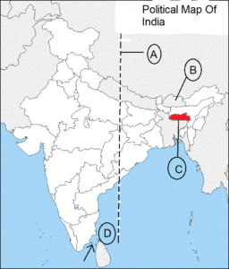
A. IST, Bhutan, Tripura, Cape Comorin
B. IST, Sikkim, Mizoram, Gulf of Kachchh.
C. IST, Bhutan, Meghalaya, Gulf of Mannar.
D. IST, Bhutan, Manipur, Indira Point
Note: Why to lose 2 marks in map when you can easily score full marks.
Check out CLASS IX TERM I MAP WORK FROM GEOGRAPHY SOLVED AS PER THE LATEST SYLLABUS
Class IX Geography Term-I MCQ’s Full Syllabus Practice Paper
Chapter 2 Physical Features Of India
Q1. Geologically, the _______________ constitutes one of the ancient landmasses on the earth’s surface. It was supposed to be one of the most stable land blocks.
A. The Northern Mountains.
B. The Northern Plains.
C. The Peninsular Plateau.
D. The Thar Desert.
Q2. The core of Great Himalayas (Himadri) is composed of ______________.
A. Granite.
B. Sedimentary rocks.
C. Unconsolidated sediments.
D. None of these.
Q3. The longitudinal valley lying between lesser Himalaya and the Shiwaliks are known as ________.
A. Kashmir valley.
B. Glaciers.
C. Punjab Himalayas.
D. Duns.
Q4. The part of the Himalayas known as Kumaon Himalayas lies between __________ rivers.
A. Indus and Satluj
B. Kaali and Teesta
C. Satluj and Kali
D. Teesta and Dihang.
Q5. Which of the following is not the part of Purvanchal hills?
A. Mizo hills.
B. Patkai Hills.
C. Naga hills.
D. Nilgiri hills.
Q6. The rivers, after descending from the mountains deposit pebbles in a narrow belt of about 8 to 16 km in width lying parallel to the slopes of the Shiwaliks. It is known as ________.
A. Doab
B. Bhabhar
C. Khadar
D. Terai.
Q7. The part of the Peninsular plateau lying to the north of the Narmada river, covering a major area of the Malwa plateau, is known as the
A. Deccan Plateau
B. Chota Nagpur Plateau
C. Central Highlands.
D. Eastern Ghats.
Q8. Match the two columns:
A B
Pitti Island – Seasonal river
Chilika – Salt water lake
Barren Island – Bird Sanctuary
Luni – Active volcanoes
Q9. Which river is not the tributary of Indus?
A. Jhelum
B. Beas
C. Tista
D. Chenab
Q10. Which one of the following is not a range of the Himalayas.
A. Pir Panjal
B. Dhaula Dhar
C. Satpura
D. Mahabharat
Class IX Geography Term-I Assertion and Reason Based Questions
Chapter 2: Physical Features Of India
Q11. Assertion: The Western Ghats are higher than the Eastern Ghats.
Reason: They are continuous and can be crossed through passes only
A. Both A and R are true and R is the correct explanation of A.
B. Both A and R are true and R is not the correct explanation of A.
C. A is true but B is false.
D. A is false but R is true.
Q12. Assertion: Luni is the only large river of Rajasthan.
Reason: It falls into the Arabian sea.
A. Both A and R are true and R is the correct explanation of A.
B. Both A and R are true and R is not the correct explanation of A.
C. A is true but B is false.
D. A is false but R is true.
Q13. Assertion: Lakshadweep Islands group lies close to the Malabar coast of Kerala.
Reason: . Earlier they were known as Laccadive, Minicoy and Amindive.
A. Both A and R are true and R is the correct explanation of A.
B. Both A and R are true and R is not the correct explanation of A.
C. A is true but B is false.
D. A is false but R is true.
Q14. Assertion: The plains along the Bay of Bengal are wide and level.
Reason: The northern part of the coast is called the Konkan.
A. Both A and R are true and R is the correct explanation of A.
B. Both A and R are true and R is not the correct explanation of A.
C. A is true but B is false.
D. A is false but R is true.
Q15. Assertion: The Himachal range is mainly composed of highly compressed and altered rocks.
Reason: It is known for beautiful hill stations.
A. Both A and R are true and R is the correct explanation of A.
B. Both A and R are true and R is not the correct explanation of A.
C. A is true but B is false.
D. A is false but R is true.
ANSWER KEY:
Chapter 1: India – Size and Location
- C. North West. 2. B. Haryana 3. C. 221 KM 4. A. Cape Comorin 5. A. Mizoram 6. B. India and Europe 7. D. Brazil 8. D. Lakshadweep
9. B. Goa 10. B. Lakshadweep 11. A. British officials. 12. B. Jharkhand 13. C. Puducherry 14. D. Eight jumps. 15. A. Northern and Eastern
16. D. Sunil (Because TamilNadu is the southernmost state) 17. D. None of the above. 18. A. Both A and R are true and R is the correct
explanation of A. 19. D. A is false but R is true. 20. C. IST, Bhutan, Meghalaya, Gulf of Mannar. (Map Question)
ANSWER KEY:
Chapter 2 Physical Features Of India
C. The Peninsular Plateau. 2. A. Granite. 3. D. Duns. 4. C. Satluj and Kali 5. D. Nilgiri hills 6. B. Bhabhar 7. C. Central Highlands.
8. i) Pitti Islands – Bird Sanctuary ii) Chilika – Salt water lake iii) Barren islands – Active volcanoes iv) Luni – Seasonal river.
9. C. Tista 10. C. Satpura 11. A. Both A and R are true and R is the correct explanation of A. 12. C. A is true but B is false.
13. A. Both A and R are true and R is the correct explanation of A. 14. C. A is true but B is false. 15. A. Both A and R are true and
R is the correct explanation of A.
Class IX Geography Term-I Full Syllabus:
Conclusion:
The purpose of writing “Class IX Geography Term – I full syllabus” is to get an idea about the type of questions which can be asked in the examination. Two Geography chapters are in the syllabus for term I. They are INDIA – SIZE AND LOCATION and PHYSICAL DIVISIONS OF INDIA – CLASS IX . You will not find such unique questions on any website or on you tube. The questions are simple but tricky. You need to have an in-depth knowledge and understanding. Unique questions have been included in “Class IX Geography Term – I full syllabus”. For the latest syllabus updates of social science , click on the given link.
Hope, “Class IX Geography Term – I full syllabus” will help each student in scoring full marks.
Do not neglect map work as it carries 10 percent marks. Check out CLASS IX TERM I MAP WORK SOLVED
Solve 3 sets of Term I Social Science (Geography) Sample Question Paper (SQP) (Average, Moderate and Difficult Level) click here.
All the Best.
Class IX Term II Climate: How to write short answers in points?

0 Comments