


WHY TO LOSE 2 MARKS IN TERM 1 MAP WORK IN CLASS IX ?
Are you afraid of Class IX term I map work? Don’t worry. It’s not so difficult. Here you will get complete guidance on map work. Moreover, “Why to lose 2 marks in term 1 map work in class IX” when you can score full marks easily. Many children hate doing map work. In many schools, map work is given as home-work. Moreover, even a few good students tend to neglect map work. Do you really think that map work is so very difficult? No, not at all. Then Why to lose 2 marks in term 1 map work in class IX?
To begin with, in this article, we are providing you with complete map syllabus and also chapter wise map work done.
With only two days of practice you will be able to score full marks in term 1 map work.
But, before we start, take a look at the new syllabus of term 1 map work given below. CBSE Class IX Geography Term -I MCQ’s Full Syllabus 2021-22 .
CLASS IX TERM 1 CHAPTER WISE MAP PROTION AS PER THE NEW RATIONALISED SYLLABUS 2021
Chapter-1: India-Size And Location
Firstly, Indian States with Capitals, Tropic of Cancer, Standard Meridian, (Location and Labelling)
Lesson No. 2: Physical Features of India
First, Mountain Ranges: The Karakoram, The Zasker, The Shivalik, The Aravali, The Vindhya, The Satpura, Western & Eastern Ghats
Second, Mountain Peaks: K2, Kanchan Junga, Anai Mudi
Third, Plateau: Deccan Plateau, Chotta Nagpur Plateau, Malwa plateau
Fourth, Coastal Plains: Konkan, Malabar, Coromandal & Northern Circar (Location and Labelling)
Chapter-3: Drainage
Note: Only map items of this chapter as listed below to be evaluated in Examination.
(a) Rivers: (Identification only)
Firstly, the Himalayan River Systems: The Indus, The Ganges, and The Satluj
Secondly, the Peninsular rivers: The Narmada, The Tapi, The Kaveri, The Krishna, The Godavari, The Mahanadi
(b) Lakes: Wular, Pulicat, Sambhar, Chilika,
CLASS IX CHAPTER WISE MAP WORK FOR REVISION
Chapter-1: India-Size And Location
Indian States with Capitals, Tropic of Cancer, Standard Meridian, (Location and Labelling)

India – Size and location Term I Map work
Important states with their capitals are marked in the Map.
These state capitals are generally asked in term 1 exams How to calculate time using longitudes explained Step by step.
Names of the states along with their capitals are marked below.
Just practice these states and capitals in the map Integrating Bihar with Tripura and Mizoram Under Ek Bharat Shreshtha Bharat.
Moreover, these are the only states and capitals which usually create confusion.
NAME OF THE STATE CAPITAL
- ARUNACHAL PRADESH ITANAGAR
- NAGALAND KOHIMA
- MANIPUR IMPHAL
- MIZORAM AIZAWL
- TRIPURA AGARTALA
- ANDHRA PRADESH HYDERABAD
- GOA PANAJI
- KARNATAKA BANGALORE
- LAKSHADWEEP (UT) KAWARATTI
- ANDAMAN & NICOBAR (UT) PORT BLAIR
Lesson No. 2 : Physical features of India
i) Mountain Ranges: The Karakoram, The Zasker, The Shivalik, The Aravali, The Vindhya, The Satpura, Western & Eastern Ghats

Class IX Physical features of India Term I Map work
According to the new map syllabus, three Himalayan ranges are in the portion.
Moreover, all are Himalayan ranges and can be easily marked as well as identified.
Apart from this there are 4 more ranges of the peninsular plateau,
Aravali range mainly lies in Rajasthan, Vindhya, Satpura and Chhota Nagpur plateau lie in central India.
Western Ghat is a long stretch of high land which lie in the western margins of Deccan plateau.
Look at the location very carefully.
You will have to identify any one from these in term 1 exams.
However, Eastern Ghats if asked to identify can easily be done.
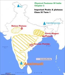
ii) Mountain Peaks and Plateaus
Firstly, Mountain Peaks: K2, Kanchan Junga, Anai Mudi
Secondly, Plateau: Deccan Plateau, Chotta Nagpur Plateau, Malwa plateau
iii) Coastal Plains:
Konkan, Malabar, Coromandal & Northern Circars (Location and Labelling)
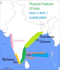
What is a sea coast?
A coast is the land near the sea.
So, in India, there are total five coastal plains.
Three on the west coast and 2 on the east coast.
But, according to the new syllabus by the board, you have to mark or identify any four.
Look at the map and practice marking all the four coastal plains of India.
Just practice once in an outline map of India.
Now, You can easily identify the coastal plain in term 1 without any difficulty.
Chapter-3: Drainage
Drainage is the water flow through well defined channels.
Moreover, Drainage pattern is an outcome nature, rocks, slope, amount of water etc.
Note: Only map items of this chapter as listed below to be evaluated in Examination.
(a) Rivers: (Identification only)
Firstly, the Himalayan River Systems: The Indus, The Ganges, and The Satluj.
Secondly, the Peninsular rivers: The Narmada, The Tapi, The Kaveri, The Krishna, The Godavari, The Mahanadi
(b) Lakes: Wular, Pulicat, Sambhar, Chilika,

Class IX Drainage Map work – Important rivers and lakes for term I
CONCLUSION:
You have a golden opportunity to score full marks in class IX term I map work https://www.learncbse.in/cbse-class-9-social-science-map-work/.
Moreover, there are only 3 chapters in class IX term I map work.
You have to identify the mountains, rivers, plateaus of your own country.
However, fifty percent of the features you all ready know.
So, only a few things you need to practice for term I map work.
However, if you identify correctly, you can easily score two marks extra in Geography term I.
Therefore, Scoring two marks extra in term I map work means scoring ten percent extra marks in Geography.
Now, is it difficult to score 10 percent marks extra in Geography? No.
Then, Why to lose 2 marks in term 1 map work in class IX” when you can score full marks easily.
Also get unique MCQ’s for term I here CBSE Class IX Geography Term -I MCQ’s Full Syllabus 2021-22 .
Good luck for your term I exams.
Was this article helpful to you?
At last, do write your views and suggestions in the comment box below.
For 3 sets of Social Science Sample Question Paper (SQP) (Average, Moderate and Difficult Level), click here.


Thank you sir very helpful
THANK YOU TANMAY. KEEP VISITING.