

How rivers, wind, glaciers, & waves shape the Earth’s surface.
In this blog post, we will learn “How Rivers, Wind, Glaciers & Waves Shape Land.” The surface of the earth is being constantly changed by natural forces. These forces are called agents of erosion and deposition. You will read about it in Class IX Geography chapter Shaping of the Earth’s Surface.”
They are always wearing down rocks, carrying sediments, and depositing them in new places. Rivers, winds, glaciers, and sea waves are some of the most important agents in shaping the landscape of the Earth. These agents create spectacular landforms over thousands and even millions of years. These influence climate, agriculture, transportation, tourism, biodiversity and human settlements.
Physical geography is important to understand the landforms created by rivers, winds, glaciers, and sea waves. It helps students identify the changing nature of the Earth and how different landscapes develop.
Class 9 Geography Shaping of the Earth’s Surface Lesson Plan as Per New NCERT Syllabus
What are Landforms?
Let us first understand what landforms are.
Landforms are the natural physical features found on the Earth’s surface.
They are created through various geological processes such as:
- Weathering
- Erosion
- Transportation
- Deposition
- Volcanic activities
- Tectonic movements
Among these, erosion and deposition carried out by natural agents play a major role in creating diverse landscapes.
How Different Agents Shape the Earth’s Surface
By and large, different agents work in different environments such as plains, mountains, deserts, and near the sea coast.
| Agent | Major Work | Regions |
|---|---|---|
| Running Water | Erosion & Deposition | Rivers, plains, mountains |
| Wind | Erosion & Deposition | Deserts and dry regions |
| Glaciers | Erosion & Deposition | High mountains and polar areas |
| Sea Waves | Coastal erosion & deposition | Sea coasts |
Moreover, you will notice that each agent produces unique landforms.
Landforms Formed by River (Running Water)
A river is one of the most powerful agents of erosion.
It begins in the mountains and flows towards the seas or oceans.
During its journey, it continuously erodes, transports, and deposits sediments.
How rivers, wind, glaciers, & waves shape the Earth’s surface.
Erosional Landforms Created by Rivers
1. V-shaped Valley
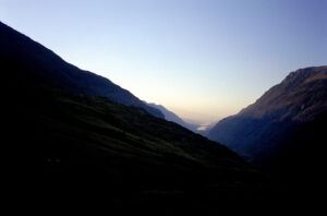
classic v shared valley with rocky hillsides and a lake in the distance
When the river slides from the mountains, it has tremendous flow.
Young rivers that flow through steep mountains cut deep into the land, forming narrow V-shaped valleys.
Characteristics
- Deep and narrow
- Steep slopes
- Fast-flowing rivers
- Common in mountainous regions
2. Gorge
A gorge is another creation by a river.
It is a deep, narrow valley with almost vertical sides.
A gorge is formed when a river cuts rapidly through hard rocks over a long period of time.
Examples
- Indus Gorge
- Kali Gandaki Gorge (Nepal)
3. Canyon
A canyon is similar to a gorge but much wider.
It develops in dry regions where rivers cut through layers of rock.
For example, the Grand Canyon (USA)
4. Waterfall
When a river falls down from a great height in the mountains, it forms waterfalls.
It develops where rivers flow over resistant rock and suddenly drop vertically.
However, continuous erosion causes waterfalls to move backward over time.
Examples
- Jog Falls
- Niagara Falls
- Victoria Falls
How rivers, wind, glaciers, & waves shape the Earth’s surface.
Depositional Landforms Created by Rivers
1. Floodplains
Floodplains are formed when rivers overflow during floods; they deposit fertile sediments along their banks.
These flat, fertile lands are called floodplains.
They are very fertile for agriculture.
Importance
- Excellent agricultural land
- Rich in nutrients
2. Meanders
When the river leaves the mountains and reaches the plains, the speed of the river decreases.
Therefore, here the river begins to bend in an “S” shape due to reduced speed.
These “S” shaped loops are known as meanders.
3. Oxbow Lakes
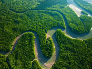
OX BOW LAKE
Sometimes, river meanders become cut off from the main river.
These isolated curved lakes are called oxbow lakes.
4. Delta
A Delta is usually formed at the last stage of a river.
At the river’s mouth, the flow of the river becomes slow, and sediments settle.
These sediments ultimately block the path of the river.
Therefore, the river breaks into numerous channels, which are called distributaries.
The river gets distributed into many branches, creating a triangular landform called a delta.
Examples
- Ganga-Brahmaputra Delta
- Nile Delta
- Mississippi Delta
How rivers, wind, glaciers, & waves shape the Earth’s surface.
Landforms Formed by Wind
Wind is an important agent in deserts where vegetation is sparse and loose sand is easily transported.
Wind performs three functions:
- Erosion
- Transportation
- Deposition
Erosional Landforms Formed by Wind
1. Rock Mushroom
Windblown sand erodes the lower half of rocks more than the upper half.
This results in mushroom-shaped rocks.
Also known as: Rock pedestals
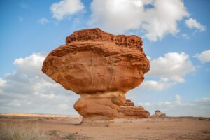
Mushroom Rocks
2. Yardangs
Yardangs are long, narrow ridges formed by wind erosion.
They are up against the prevailing winds.
3. The Deflationary Abyss
Strong winds blow away loose sand and soil and form shallow depressions known as deflation hollows.
Depositional Landforms Formed by Wind
1. Dunes
The wind blows sand as it slows down.
These form sand hills called sand dunes.
They include:
Barchan sand dunes
Longitudinal dunes 2.
Transverse dunes
2 Loess (de)
Fine dust whipped by the wind settles over large areas.
This rich deposit is known as loess.
Located in
China Europe North America
Glacier Formed Landforms
Glaciers are huge moving masses of ice that occur in mountain and polar regions.
Glaciers move very slowly but are very powerful agents of erosion.
How rivers, wind, glaciers, & waves shape the Earth’s surface.
Erosional Landforms Formed by Glaciers
1. Cirque
A bowl-shaped hollow formed at the head of a glacier.
2. U-shaped Valley
Unlike rivers, glaciers widen and deepen valleys.
This creates broad U-shaped valleys.
3. Hanging Valley
A smaller glacier joins a larger glacier at a higher level.
After melting, the smaller valley appears hanging above the main valley.
Waterfalls often develop here.
4. Fjord
When glaciers carve deep valleys that later fill with seawater, fjords are formed.
Examples
- Norway
- New Zealand
Depositional Landforms Formed by Glaciers
1. Moraine
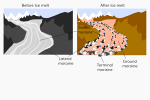
Moraines deposited by the glacier.
As glaciers melt, they deposit rocks, gravel, and soil.
These deposits are called moraines.
Types include:
- Lateral moraine
- Terminal moraine
- Medial moraine
- Ground moraine
2. Drumlin
Smooth, elongated hills formed from glacial deposits.
3. Esker
Long winding ridges of sand and gravel deposited by streams flowing beneath glaciers.
Landforms Formed by Sea Waves
Sea waves continuously shape coastlines by erosion and deposition.
The intensity depends upon:
- Wave energy
- Rock type
- Tides
- Ocean currents
How rivers, wind, glaciers, & waves shape the Earth’s surface.
Erosional Landforms Formed by Sea Waves
1. Sea Cliff
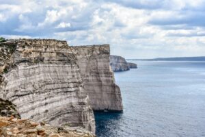
SEA CLIFF
When strong sea waves erode coastal rocks.
It produces cliffs.
Cliffs are usually vertical, like a wall in the sea.
2. Sea Cave
Continuous erosion hits a large rock, which turns it into caves.
The cracks turn into caves.
3. Sea Arch
Further erosion connects two caves or cuts through a headland, forming a sea arch.
4. Sea Stack
When the arch collapses, an isolated rock pillar remains.
This is called a sea stack.
Depositional Landforms Formed by Sea Waves
1. Beach
Sea waves deposit sand.
This sand, pebbles, and shells deposited by waves form beaches.
Sea Beaches are among the most popular tourist attractions.
2. Lagoon
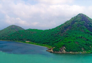
CHILIKA LAKE
A sandbar is created near the sea that separates the sea.
It is connected from one place where the sea water enters, forming a lake.
When a spit cuts off part of the sea, a shallow water body forms behind it.
This is called a lagoon.
3. Barrier Island
Long offshore deposits of sand running parallel to the coast.
They protect coastlines from strong waves.
Comparison of Landforms Formed by Different Agents
| Agent | Erosional Landforms | Depositional Landforms |
|---|---|---|
| Running Water | Valleys, Gorges, Canyons, Waterfalls | Flood Plains, Meanders, Oxbow Lakes, Deltas |
| Wind | Mushroom Rocks, Yardangs, Deflation Hollows | Sand Dunes, Loess |
| Glaciers | Cirques, U-shaped Valleys, Hanging Valleys, Fjords | Moraines, Drumlins, Eskers |
| Sea Waves | Sea Cliffs, Caves, Arches, Stacks | Beaches, Spits, Lagoons, Barrier Islands |
Importance of These Landforms
Landforms formed by natural agents are valuable in many ways.
- Support agriculture through fertile floodplains.
- Provide freshwater resources.
- Promote tourism and recreation.
- Help scientists study Earth’s history.
- Influence climate and ecosystems.
- Offer habitats for plants and animals.
- Protect coastlines from storms.
- Support fishing and transportation.
Interesting Facts
- The Grand Canyon took millions of years to form through river erosion.
- The Ganga-Brahmaputra Delta is the largest delta in the world.
- Glaciers store nearly 69% of Earth’s freshwater.
- Some sand dunes move several metres every year due to strong winds.
- Norway is famous for its spectacular fjords created by glaciers.
Conclusion
Landforms created by rivers, winds, glaciers and sea waves show the enormous power of natural processes to shape the Earth’s surface. Rivers shape valleys and form fertile plains. Winds shape dunes and rock formations in deserts. Glaciers carve magnificent U-shaped valleys and moraines.
The waves of the seas constantly change the shape of the shores by erosion and accumulation. By studying the landforms created by rivers, winds, glaciers, and sea waves, students can learn how landscapes change over time and why different regions of the world have unique physical features.
This information forms the basis of physical geography and helps us understand the dynamic, ever-changing nature of our planet.
Was this article helpful to you? Write your views in the comment box given below.




0 Comments