

Introduction

GEOGRAPHY BOARD EXAM CLASS X REVISION WITH MAPS
Are you in class X ? Are you aware of the latest changes made by CBSE in the Question pattern? Do you have Geography Board Exam – X revision plan. If not, this is the time to update your self. CBSE is increasing the difficulty level day by day. Old method of rote learning will not work now. Therefore, you need to adopt a different method for Geography revision. Here, we have tried to frame questions from every paragraph.
Important information on new pattern of question paper:
This year in Geography there will be five MCQ’s of one mark each. Board has also introduced source based questions this year. Therefore, there will be four questions each of one mark as source based question from a certain paragraph. Map will contain three marks which will include identification and marking on the political map of India. MCQ’s, source based questions and map will contain 12 marks out of twenty..
Chapter 1 Resources and development
Q1) A resource is technologically accessible, economically ______________ and culturally _____________ .
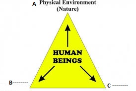
Q2. Complete the diagram:
Q 3. Resources are a function of human activities. Justify.
Q 4. Human beings themselves are essential components of resources. Justify.
Q 5. Complete the table:
A. On the basis of origin, resources are classified as ___________ and _________________
B. On the basis of status of development, resources are classified as
A________________ , B developed, C _____________________ and D reserves.
Q 6. Match the two columns:
A B
i) Coal – Non renewable
ii) Iron Ore – Potential
iiii) Burial ground – community
iv) Tidal energy – Biotic
Q 7. National resource of India lies within ________________nautical miles from the coast
Q8. The oceanic resources beyond ___________________ nautical miles is termed as International resource.
Q9. India has got the right to mine _______________ from ______________- sea/ocean.
Q 10. The first International earth summit was held in the year ___________ in _____________________.
Q 11. What was the main objective of Agenda 21?
Q12. Identify the wrongly matched pair:
A B
a) Rajasthan – Isolated from rest of the country.
b) Madhya Pradesh – Rich in minerals.
c) Arunachal Pradesh – Rich in wind and solar energy.
d) Ladakh – Deficient in water resources.
Q13. Arrange the three stages of Resource Planning in sequence.
(i) identification and inventory of resources across the regions of the country. This involves surveying, mapping etc.
ii) Matching the resource development plans with overall national development plans.
iii) Evolving a planning structure endowed with appropriate technology,
Q14. Identify a state which is resource rich but economically backward.
a) Bihar
b) Orissa
c) Punjab
d) Gujarat
Q15. Gandhiji was against ___________ production but wanted to replace it with the ______________ by the masses.
Q 16. khadar is found close to which of the following features.
a) Hills
b) Coast
c) Rivers
d) forests
Q 17. India has ________________ % of plain land and ____________ % of plateau land.
Q 18. Which one of the following is not a human factor that determine the use of land ?
a) Population density and technology.
b) Culture and traditions.
c) Topography and climate
d) Soil and technology.
Q 19. A land which is left uncultivated for one or less than one agricultural season is called ___________
- Current fallow land
- Other than current fallow land.
- Culturable waste land.
- Net sown area.
Q 20. The total Geographical area of India is _________ million sq km.
Q 21. Identify the factor which will not solve the problem of land degradation.
- Afforestation
- Shelter belts.
- Quarrying
- Stabilization of sand dunes
Q 22. Which factor is responsible for land degradation in Gujarat and Maharashtra?
- Over grazing
- Over irrigation
- Mining
- Water logging
Concept based questions:
Q 23. Alluvial soil is more fertile as it contains adequate proportion of Potash, _________ acid and _________ .
Q 24. Which factor is not responsible for Global ecological crisis?
(a) Depletion of resources for satisfying the greed of few individuals.
(b) Accumulation of resources in few hands.
(c) Sustainable economic development.
(d) Indiscriminate exploitation of resources.
Q 25. Mountains हिमालय account for ____________ percent of the total surface area of the country.
(a) 17%
(b) 27%
(c) 30%
(d) 43%
Q 26. Which one of the following statements is correct as regard to international resources?
(a) Resources which are regulated by international institutions.
(b) Resources which lie beyond the territorial waters.
(c) Resources which are found along the international frontier.
(d) Resources which are not yet developed.
Q 27. The third stage of Resource Planning involves
(a) Identification and inventory of resources.
(b) Matching the resource development plan with overall National Development plan.
(c) Evolving a planning structure endowed with appropriate technology.
(d) Qualitative and quantitative estimation and measurement of the resources.
ASSERTION AND REASON
Q 28. In the following questions a statement of Assertion (A) is followed by a statement of Reason (R).
Identify and mark the correct choice.
Assertion: Running water cuts through the clayey soils and makes deep channels such as gullies.
Reason: In the Chambal basin such lands are called Leaching.
Options:
- Both A and R are true and R is the correct explanation of A.
- Both A and R are true and R is not the correct explanation of A.
- A is true but B is false.
- A is false but R is true.
Q 29. Assertion: Laterite soils are not very fertile because it lacks micro organisms.
Reason: They are made suitable for cultivation with adequate doses of manures and fertilizers.
Options:
- Both A and R are true and R is the correct explanation of A.
- Both A and R are true and R is not the correct explanation of A.
- A is true but B is false.
- A is false but R is true.
Q 30. Assertion: Black soils are black in colour due to diffusion of iron in crystalline and metamorphic rocks.
Reason: They develop deep cracks during hot weather.
Options:
- Both A and R are true and R is the correct explanation of A.
- Both A and R are true and R is not the correct explanation of A.
- A is true but B is false.
- A is false but R is true.
HOTS Questions
Q 31. How can soils in drier areas be more productive?
a) By Contour ploughing
b) Terrace farming
c) By proper treatment and irrigation
d) By making shelter belts.
Q32. Materials in the environment which have the potential to satisfy human needs but human beings do not have the appropriate technology to access these are called
a) Stock
b) Reserve
c) Potential
d) Developed
Q 33. Which river in India is responsible for making land unfit for cultivation by creating ravines?
a) Son
b) Kosi
c) Chambal
d) Narmada
Q 34. Red soil looks yellow SOILS OF INDIA when it occurs in
a) Original form
b) Degraded form
c) Oxidized form
d) Hydrated form.
Q 35. Identify the appropriate reason for the reddish colour of the red soil?
a) Heavy rainfall
b) Intense leaching
c) Diffusion of iron in crystalline and metamorphic rocks.
d) Deposition of the sediments by the rivers.
Map work for revision

Chapter 1: Resources and Development
(Identification only)
Map portion – Major soil types:
- Alluvial soil
- Black soil
- Red soil
- Laterite soil
- Montane soil
- Arid/desert soil
NOTE: Only identification of the soil will be asked in the Board exam.
- Soil ls of the Northern and Eastern coastal plains, Black soil and Red soil cover a large area on the map and is therefore never asked in the exam.
- Questions are mainly asked from these patches as shown in the map.
- Most important ones are the soils found in the North-Eastern regions of India as there are many soils.
- This much preparation should be more than enough from this chapter.
Chapter 3 Water resources: Locating and Labelling (Only map)
Dams:
a. Salal
b. Bhakra Nangal
c. Tehri
d. Rana Pratap Sagar
e. Sardar Sarovar
f. Hirakud
g. Nagarjuna Sagar
h. Tungabhadra.
MAP WORK AS PER CBSE BOARD SYLLABUS 2020-21

MAP PORTION FROM WATER RESOURCES – GEOGRAPHY REVISION PLAN
CHAPTER 4 AGRICULTURE:
Q 1. What percentage of Indian population is engaged in agriculture. (Paragraph 1)
Ans) a) 1/3 b) 2/3 c) 3/2 d) 1/4
Q 2. Which of the following methods have been changed depending upon the characteristics of Physical environment, technical know-how, and socio-cultural practices. ( Paragraph 2)
a) Irrigation pattern b) Industrial activity c) cultivation d) None of these.
Q 3. Tools like hoe, dao and digging sticks, are used in which type of farming? ( Paragraph 3)
a) Primitive Subsistence Farming b) Subsistence Farming c) Commercial Farming d) Mixed Farming
Q 4. Identify the wrongly matched pair: (Paragraph 6)
A B
Madhya Pradesh – Dahiya
Andhra Pradesh – Pendu
Jharkhand – Roca
Chhattisgarh (Bastar) – Dipa
Q 5. Which type of farming is practiced in areas of high population pressure on land ? (Paragraph 8)
A. a) Primitive Subsistence Farming b) Subsistence Farming c) Intensive Subsistence Farming d) Commercial Farming
Q 6. What makes Intensive subsistence farming uneconomical ? (Para 8)
a) Lack of manure b) Government policy c) Right to in heritance d) Consolidation of land holding
Q 7. Which crop is a commercial crop in Haryana and Punjab, but a subsistence crop in West Bengal. (Para 9)
a) Rice b) Wheat c) Jute d) Cotton
Q 8. Which one of the following is not a feature of plantation agriculture? (Para10)
a) It is a type of commercial farming.
b) Tea, coffee and rubber are important plantation crops.
c) Two to three crops are grown in a large area.
d) Requires developed network of transport and communication.
Q 9. What is “Boro”?
a) Kharif crop’
b) Rabi crop
c) Zaid crop
d) Millet
Q 10. Which of the following is a Zaid crop?
a) Bajra
b) Moong
c) Cucumber
d) Soyabean.
Map 1- Agriculture: Major wheat and Rice producing areas

WHEAT AND RICE PRODUCING AREAS
B. Fill in the blanks:
11 __________ is a staple food crop of a majority of people in India.
12. Aus, Aman and Boro are types of _____________ crop.
13. ______________ are also called coarse grains.
14. ____________ is used in making gunny bags, ropes, mats, carpets and other artefacts.
15. India is the second largest producer of sugarcane only after ________________.
16. The crop that is used both as food and fodder is ______________.
17. khandsari and molasses are the byproduct of ____________________.
18. _____________ is a kharif crop and accounts for about half of the major oilseeds produced in the country.
19. The ______________ oil seed is grown both as rabi and kharif crop.
20. The _______________________variety of coffee was initially brought from Yemen is produced in the country.
Match the following:
21. A B
Jute – Oilseed
Tea – Plantation crop
Jowar – Fibre crop
Castor – Millet
Rubber – Beverage crop
22. Match the following:
A B
Guavas – Kerala
Pineapples – Maharashtra
Bananas – Uttar Pradesh
Oranges – Kashmir
Walnuts – Meghalaya
23. Correct the underlined word:
i) Coffee cultivation was introduced on the Nilgiri Hills
ii) Bhoodan and Gramdan was initiated by Baba Amte.
iii) White revolution was associated with flood control.
iv) “Green Revolution” was the main focus of our First Five Year Plan.
v) Personal Agriculture Insurance Scheme (PAIS) was introduced for the benefit of farmers.
24. Assertion and reason
In the question given below, there are two statements marked as Assertion (A) and Reason (R). Read the statements and choose the correct option:
Assertion (A): Indian agriculture is the gamble in the hands of monsoon.
Reason (R) Indian farmers carry out and follow diversified type of farming.
Analyze the given statements labelled as Assertion (A) and Reason (R), In the context of the two statements which of the following is correct?
A. Both A and R are true and R is the correct explanation of A.
B. Both A and R are true but R is not the correct explanation of A
C. A is correct but R is wrong.
D. A is wrong but R is correct.
25. Assertion (A): Pulses are grown in rotation with other crops.
Reason (R) It helps in restoring soil fertility by fixing nitrogen from the air.
Analyze the given statements labelled as Assertion (A) and Reason (R), In the context of the two statements which of the following is correct?
A. Both A and R are true and R is the correct explanation of A.
B. Both A and R are true but R is not the correct explanation of A
C. A is correct but R is wrong.
D. A is wrong but R is correct.
Map from Agriculture as per CBSE:
B. ) Largest / Major producer states of Sugarcane; Tea; Coffee; Rubber; Cotton and Jute.
 GEOGRAPHY REVISION")
MAJOR CROPS WITH LARGEST PRODUCING STATES
Chapter 5 Minerals and Energy resources (Only map)
Note: Only Map Items of this chapter as listed below will be evaluated in Board Examination.
Power Plants:
(Locating and Labelling only)
(a) Thermal:
Namrup
Talcher
Singrauli
Harduaganj
Korba
Uran
Ramagundam
Vijaywada
Tuticorin
(b) Nuclear:
Narora
Rawat Bhata
Kakrapara
Tarapur
Kaiga
Kalpakkam
, GEOGRAPHY REVISION")
NUCLEAR & THERMAL POWER PLANTS
Chapter 6 Manufacturing Industries
1, Production of goods in large quantities after processing from raw materials to more valuable products is called _______________.
2. Manufacturing industries fall in the ________________ sector. (Primary/ Secondary/ Tertiary)
3. The main philosophy behind public sector industries and joint sector ventures in India was
i) Eradication of unemployment and poverty.
ii) To expand trade and commerce to earn foreign currency.
iii) bringing down regional disparities by establishing industries
iv) To reduce heavy dependence of people on agriculture.
Options:
A. i and ii
B. ii and III
C i and iii
d) II and iv
4. . Many industries tend to come together to make use of the advantages offered by the urban centres known as ______________ economies.
5. According to their main role an industry can be classified as _________________ and __________________ .
6. Complete the following table.
| On the basis of ownership, an industry can be classified as: |
| i) Public sector Ii) Private Sector iii) _____________________ iv) _________________________ |
7. Identify the wrongly matched pair.
a) Public sector – BHEL, SAIL
b) Private sector – Dabur and Bajaj
c) Joint Sector – Coir industry in Kerala.
d) Co-operative sector – Sugar industry in Maharashtra.
8. Correct the word written in bold and rewrite the following sentence.
The first successful textile mill was established in Ahmedabad in 1854.
9. When was the National Jute Policy formulated?
a) 1947 b) 1965 c) 2005 d) 2011
10. What happened to Jute industry after partition in 1947?
i) Major Jute producing area went to Pakistan.
ii) Major Jute industries went to Bangladesh.
iii) More than one lakh workers migrated to Bangladesh.
iv) Three-fourth of the jute producing area went to East Pakistan.
Concept based questions:
11. Which mineral/ metal is used in the manufacturing of aircraft, utensils and wires?
i) Aluminium ii) Copper iii) Steel iv) Manganese.
12. National Jute Policy was formulated with the objective of _________
a) increasing productivity,
b) ensuring good prices to the jute farmers
c) enhancing the yield per hectare.
d) All of the above.
13. In recent years, there is a tendency for the mills to shift and concentrate in the southern and western states because
a) the soil of southern and western states are more fertile.
b) it is easy to import raw material in southern and western states
c) Cooler climate ensures a longer crushing season.
d) People of Northern states are not interested in growing sugarcane.
14. In the making of steel Iron ore, coking coal and lime stone are required in the ratio of_______
a) 1:2:4 b) 4:2:1 c) 2:4:1 d) 4: 1 :2
15. Which industry is the largest consumer of chemical industry?
a) Fertilizer industry
b) Paint industry
c) Adhesive industry
d) Chemical industry.
16. The first cement plant was set up in ________________ in 1904.
a) Hugli
b) Chennai
c) Kolkata
d) Mumbai.
17. ________________ has emerged as the electronic capital of India.
a) Hyderabad
b) Mysore
c) Bangalore
d) Gurgaon
18. Business Processes Outsourcing is an example of _______ industry in India.
19. ____________________pollution occurs when hot water from factories and thermal plants is drained into rivers and ponds before cooling.
a) Thermal pollution
b) Water Pollution
c) Air Pollution
d) Noise Pollution.
20. Noise pollution can result in
a) irritation and anger,
b) cause hearing impairment,
c) increased heart rate and blood pressure
d) All of the above.
Application based questions
21. Which of the following is a mineral based industry?
A. Jute industry
B. Coffee industry
C. Textile industry
D. Petrochemicals industry
22. Which organization is responsible for the marketing of steel of the public sector undertaking?
A. IISCO
B. BHEL
C. SAIL
D.TISCO
23. Which is the only industry in India which is self-reliant?
A. Iron and steel
B. Automobile
C. Textile
D. Electronics
24. Which of the following do not come under electronic industries?
A. Locomotives
B. Radars
C. Cellular phones
D. Telephones
25. Identify the industry which is not responsible for water pollution?
A. Paper Pulp
B. Sugar
C. Textile and dying
D. Leather industry (Tanneries)
26. Ginning, Spinning, Designing and Weaving are associated with_____________?
A. Jute industry
B. Sugar industry
C. Leather industry
D. Cotton Textile industry
HOTS Questions
27. Which of the following statements is not correct regarding spinning sector in India?
A. Spinning mills are mostly located in Maharashtra, Gujarat and Tamil Nadu.
B. India has world-class production in spinning.
C. Our spinning mills are capable of using all the fibres we produce.
D. Most of the yam we produce is used by our local weavers.
28. Which is a prime factor for the location of Aluminium industry?
A. Market and labour
B. Transport network and water supply
C. Cheap and regular supply of electricity and bauxite
D. None of the above
29. Which of the following factors are not necessary to set up an iron and steel plant?
A. Proximity to iron-ore mines
B. Availability of coking coal
C. Availability of resources like limestone and manganese
D. Nearness to a water body to discharge wastes
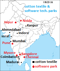
30 The Software Technology Parks are set up by the government to provide
(a) Skilled software professionals
(b) Capital to start a software company
(c) Single window service and high-speed data communication facility to software experts
(d) None of the above
MAJOR STEEL CITIES IN INDIA AS PER CBSE BOARD SYLLABUS

STEEL PLANTS IN INDIA, GEOGRAPHY BOARD CLASS X
Chapter 7 Lifelines of National economy
Roadways
- Which one of the following will not come under land transport?
a) Roadways
b) Railways
c) Inland waterways
d) Pipelines.
2. The construction cost of roads is
a) much lower than that of railway lines.
b) much higher than that of railway lines.
c) equal to the construction coat of railway lines.
d) None of the above.
3. The North-South corridors link
a) Jammu to Kanyakumari
b) Silchar to Porbandar
c) Srinagar to Kanyakumari
d) Varanasi to Kanyakumari
4. The Golden Quadrilateral Super Highway Projects are implemented by
a) Central Public Works Department (CPWD)
b) State Public Works Department (SPWD)
c) National Highway Authority of India (NHAI)
d) Pradhan Mantri Grameen Sadak Yojna
5. The longest National Highway in India is
a) NH 1
b) NH 7
c) NH 11
d) NH 13
5. What is the major objective of the Super Highways?
a) To reduce the load and compete with Indian Railways.
b) To reduce time and distance between Mega cities.
c) To break inter-state barriers.
d) To compete with European countries.
6. Border Road Organization (BRO) was established in the year
a) 1960
b) 1965
c) 1970
d) 1975
7. The length of road per 100 sq. km of area is known as
a) Length of roads.
b) density of roads.
c) Volume of roads.
d) Congested roads.
Railways
8. The first train in India started from Mumbai to Thane in the year _________________
a) 1773
b) 1833
c) 1853
d) 1873
9. Which one of the following is not a railway gauge?
a) Broad Gauge
b) Metro Gauge
c) Narrow Gauge
d) Meter Gauge.
10. The distance between the two tracks in Broad Gauge is
a) 0.762 m
b) 1.000 m
c) 1.676 m
d) 1.762 m
11. Konkan railway lies in the
a) Himalayan mountainous region
b) west coast of India.
c) East coast of India
d) Thar desert region.
12. The northern plains have the most favorable condition for the growth of railways because of
a) their vast level land,
b) high population density
c) rich agricultural resources
d) All of the above.
13. The problem faced by Indian Railways in the Northern Plains is
a) hilly terrains.
b) in making tunnels.
c) construction of bridges over wide rivers.
d) sinking of tracks in marshy areas.
14. _______________ transport network is a new arrival on the transportation map of India.
a) Roadways
b) Pipelines
c) Inland waterways.
d) Airways.
Pipelines
15. The biggest advantage of pipeline transportation is
a) it rules out trans-shipment losses.
b) it is very economical.
c) all three, solid, liquid and gas can be transported.
d) easy to construct.
16. Solids can also be transported through a pipeline when converted into
a) Liquid
b) Gas
c) slurry
d) small pieces.
17. Which one of the following is not among the three important networks of pipeline transportation in the country?
a) Assam to Kanpur
b) Salaya in Gujarat to Jalandhar.
c) Bombay High to Digboi in Assam
d) Hazira in Gujarat to Jagdishpur in U.P.
18. Which statement is not correct about Pipeline transportation ELON MUSK’S VIRGIN HYPERLOOP?
a) It can be constructed on land and water
b) Construction cost is low but maintenance cost is high.
c) Construction cost is high but it’s running cost is low.
d) Transportation is easy but trans-shipment cost is high.
NOTE: Have you heard about Elon Musk’s Hyperloop transportation system.
Waterways
19. National waterway Number 1 lies between
a) Patna and Kolkata
b) Varanasi and Hugli
c) Allahabad and Haldia
d) Kanpur and Hugly.
20. National Waterway Number 2 is associated with which river?
a) Ganga
b) Gogawari
c) Mahanadi
d) Brahmaputra
21. India has inland Navigation Waterways of _______________ km in length.
a) 14,500
b) 12,500
c) 16,720
d) 18,500
22. Waterways are the cheapest means of transport. They are most suitable for carrying __________________ goods.
a) Breakable
b) Perishable
c) Liquid
d) Heavy and Bulky
23. India has a long coastline of approximately _______________ km
a) 6716.6
b) 7616.6
c) 1676.6
d) 6617.6
Sea ports
24. India’s major seaports handle ________ percent of total exports.
a) 65
b) 78
c) 95
d) 100
25. The first port developed soon after Independence was__________________
a) Haldia
b) Kandla
c) Vishakhapatnam
d) Chennnai.
26. Which is the premier iron ore exporting port of the country that accounts for about fifty percent of India’s iron ore export.
a) Kandla
b) Marmagao
c) Kocchi
d) New Mangalore.
27. Which is the oldest artificial sea port of India?
a) Kolkata
b) Mumbai
c) Chennai
d) Vishakhapatnam
28. Name the deepest landlocked and well-protected port of India.
a) Chennai
b) Paradweep
c) Kocchi
d) Vishakhapatnam
29. Name an inland riverine port of India.
a) Mumbai
b) Kolkata
c) Tuticorin
d) Chennai
30. Which sea port caters to the export of iron ore from Kudremukh mines?
a) Kocchi
b) New Mangalore
c) Marmagao
d) Tuticorin

SEA PORTS AND INTERNATIONAL AIRPORTS, CLASS X
Airways:
31. Which six cities have the major International airports in India.
a. Delhi, Kolkata, Chennai, Mumbai, Pune, Hyderabad.
b. Delhi, Kolkata, Chennai, Mumbai, Hyderabad, Lucknow.
c. Delhi, Kolkata, Chennai, Mumbai, Amritsar, Thiruvananthapuram
d. Delhi, Kolkata, Chennai, Mumbai, Bangalore, Jaipur
32. Name the Northernmost International airport of India.
a) Netaji Subhash Chandra Bose International Airport.
b) Raja Sansei International Airport.
c) Indira Gandhi International Airport.
d) Chhatrapati Sivaji International Airport.
33. The air transport was Nationalized in the year ______________
a) 1951
b) 1953
c) 1955
d) 1957
34. The most preferred mode of transport in North-Eastern states of India is ____________________
a) Roadways
b) Railways
c) Waterways
d) Airways.
35. What important role does Pawanhans Helicopter Ltd. play.
a) Provides service to ONGC in it’s off shore operations.
b) Provides safety and security to India.
c) Carrying passengers in North-Eastern parts of India.
d) Helps in improving trade relations with neighboring countries.
COMMUNICATION:
36. Which one of the following is a means of personal communication.
a) Books and magazines.
b) Radio and Television
c) Letters and mobile phones.
d) Cinema and Internet.
37. Which one of the following is not the means of mass communication?
a) Films
b) Radio
c) Newspaper
d) Letters and envelopes
38. STD refers to
a) State Telephone Dialing
b) Subscriber Trunk Dialing
c) Subscriber Telephone Distributors
d) Speed Telephone Dialing
39. The first-class mail includes which one of the following?
a) Book packets
b) Envelopes and cards
c) Registered newspaper and cards
d) Periodicals and journals
40. Which of the following is not a means of communication?
(a) Radio
(b) Press
(c) Roads
(d) Films
41. Maximum numbers of newspapers published in India are in ______________ .
a) Hindi
b) English
c) Urdu
d) Tamil
42. Which authority certifies India and foreign films in India.
a) Central Board of Secondary Education
b) Central Board of Film Certification
c) Central Board of Film Censorship
d) Ministry of Information and Distribution
Conclusion:
Is it possible to revise Geography in just one week? Yes, if you are aware about the changes made by CBSE in the question paper. You don’t need to study hard but to score good you need to study smartly. You must be aware about the pattern of the question paper as mentioned in the second paragraph. Also practice map once. With this you can confidently take up the Board exams. Geography revision plan can help you prepare for your exams in just one week.


0 Comments