Are You Still Confused Between Latitudes And Longitudes?
If you hold a map or globe in your hands, you will see many lines of Latitudes and Longitudes on it. These lines of Latitudes and Longitudes on Globe/map are very important. They help us to locate the exact location of a place on earth. Today, in this article, you will read about all the important Lines of Latitudes and Longitudes.
Contents:
- Lines of latitudes.
- What is in between two latitudes?
- What are some important lines of latitudes.
- Lines of longitudes
- Calculating time with the help of longitudes.
- Finding latitude and longitude of a place in an Atlas.
- India’s latitudinal and longitudinal extent.
- How latitude and longitude help GPS work.
- Conclusion
1. Lines of latitudes
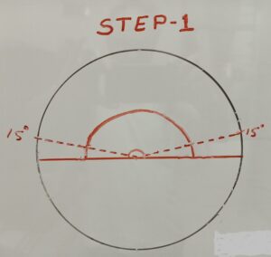
LINES OF LATITUDES – HAND MADE
What are Latitudes and how to draw it?
The lines which you see from West to East are the Lines of Latitudes.
If you want to know the definition of Latitude then
“it is the angular distance of a place from the center of the earth.”
What did you understand from the definition?
Draw a circle on a piece of paper.
Every circle will have a center point, mark it.
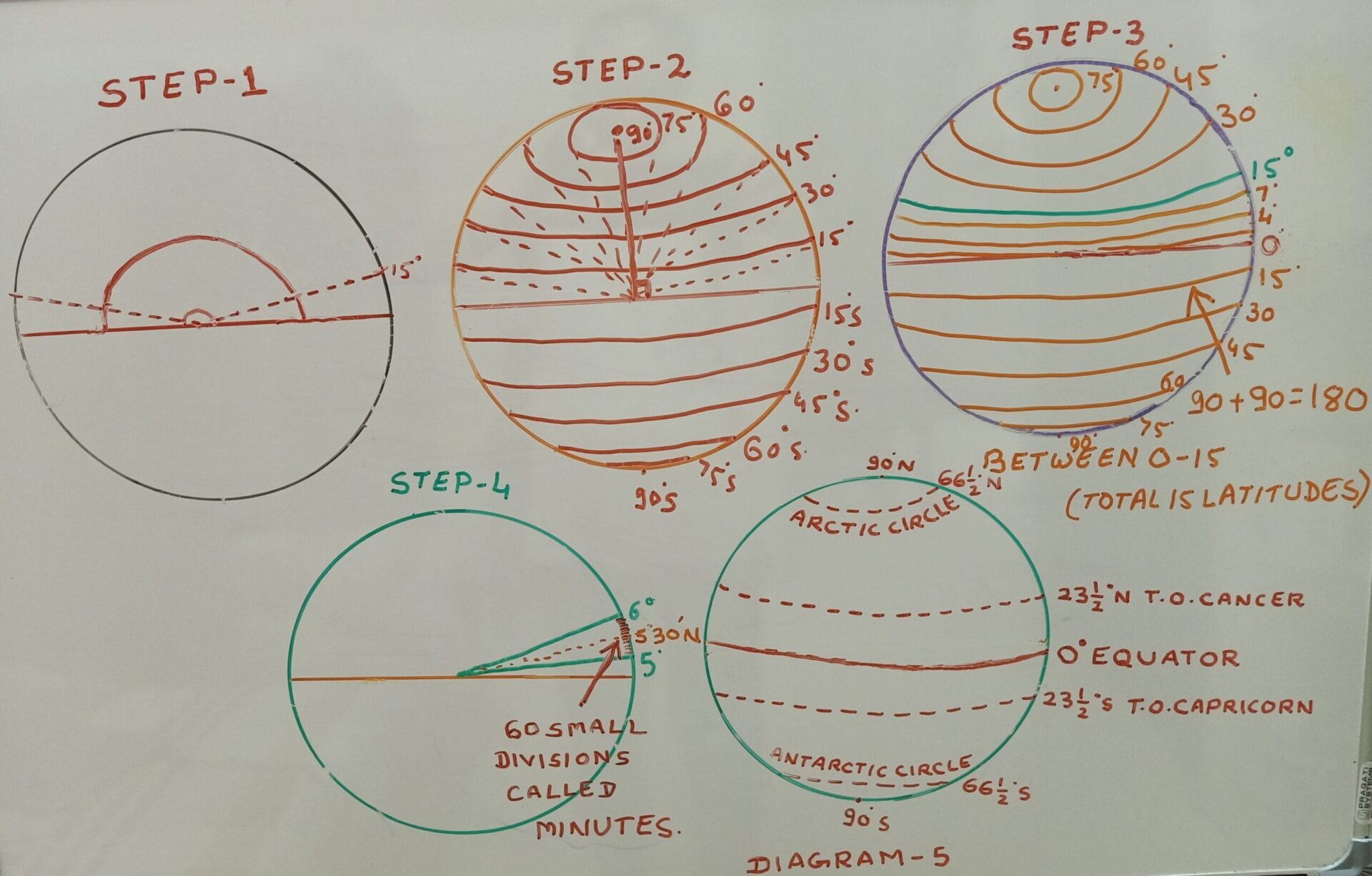
Now, draw a straight line passing through the center (as shown in step 1.)
Keep the protector at the center and mark 15 degrees.
Just put a dot at 15 degrees.
Join 15 degree dot with the center of the circle.
Similarly mark 15 degrees on the other side.
Join both the 15 degree points with the help of a scale.
This is 15 degree latitude. (as shown in step 2)
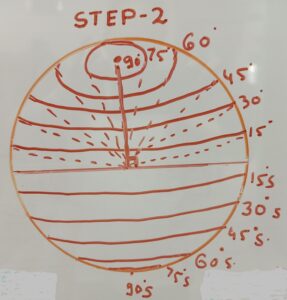
DRAWING OTHER LINES OF LATITUDES
similarly, you can draw 30, 45, 60, 75 and 90 degrees. (as shown in step 2)
Is your 30 degree latitude making an angle of 30 degree from the center of the earth.
It means,
30 degree latitude tells us about the places which are located at an angle of 30 degrees from the center of the earth.
Easy.
Now read the definition of Latitude once again.
It says
“it is the angular distance of a place from the center of the earth.”
ii) Knowing about Latitudes in details:
2. What is in between two latitudes?
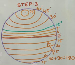
BETWEEN THE LINES OF LATITUDES
Now you have learnt how to draw a 15 degree latitude.
Do you think from 0 degree there is directly 15 degrees. No. (as shown in step 3)
There is 10 degree, 5 degree, 4,3,2,1 degrees also.
Latitudes are from 1 degree to 90 degrees above the center line of your circle.
Similarly, there are 1 degree to 90 degrees below the center line of your circle.
Therefore, total number of Latitudes are 90 + 90 = 180. (as shown in step 3)
Now let’s understand what are between the two latitudes?
Take any two latitudes say 5 degrees and 6 degrees. (as shown in step 4)
As you see in your watch between 5:00 and 6:00 there are 5 further small divisions called minutes as we say 5 hrs. and 7 minutes.
Similarly, between 5 degree and 6 degree there are 60 small divisions called as minutes. (as shown in step 4)
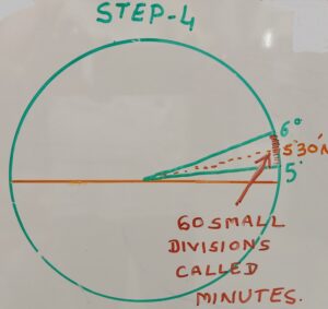
MARKING MINUTES BETWEEN TWO LATITUDES
If a place is located between 5 degree and 6 degree latitude, it will be written as 5°30′ N and will be read as (Five degree and 30 minutes North).
The distance between two latitudes on earth is 69 miles or 110 km.
Therefore, mistake of 1′ (one minute) means shift of a place by almost 2 km from its exact location on earth.
Remember that these lines are also called the LINES OF PARALLELS.
Now try to find out the Latitudinal extent of India?
3. What are some important lines of latitudes. (Diagram 5)
In case of latitudes, few lines of latitudes are very important.
For Example 0° Latitude is called Equator.
It is at the center of globe and divides the earth into two hemispheres.
Above the equator it is entirely Northern hemisphere below the equator it is entirely Southern Hemisphere.
What are the other important latitudes? This question must be coming in your mind.
Other important latitudes are 23 1/2° North which is Tropic of Cancer and 23 1/2° South which is Tropic of Capricorn.
Why are they important?
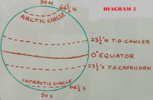
IMPORTANT LINES ON GLOBE
To understand this, let’s do an experiment.
Take a ball and a torch.
Switch on the torch and let the light fall at the center. What do you see?
You will see that bright rays of the torch light falls on and near the equator.
Medium light above Tropic of cancer i.e. 231/2° North to 661/2°North and 231/2° South to 661/2°South.
Minimum light will fall at the two extreme ends of North and South poles at 90°.
Now, the same thing happens when the sun’s rays fall on the earth.
Therefore, places located on or near the equator are extremely hot.
Places located above and below the tropics have medium temperatures and places located at extreme North or South have very Low temperatures.
In this way,
the importance of these Latitudes are that they divide the earth into three temperature zones – Torrid, Temperate and Frizid.
i) From 0° Equator to 231/2° North and 231/2° South – TORRID ZONE.
ii) 23 1/2° North (Tropic of Cancer) to 66 1/2° North (Arctic circle) – Temperate Zone
23 1/2° South (Tropic of Cancer) to 66 1/2° South (Antarctic circle) – Temperate Zone and
iii) 66 1/2° North and South to 90° North and South – Frizid Zone.
4. Lines of longitudes
The lines which run from North to South are called Longitudes..
0° Longitude, which passes through Greenwich near London is called Prime Meridian.
How these Longitudes were drawn?
Our earth is spherical in shape. It means 360° circle.
We got 0° at Greenwich. The longitude on the other side of 0° will be 180° (Half circle).
Now, from the center of the earth, each degree was marked.
This is how we got 360 lines (semi circles) as the lines of meridian.
These meridians are used to locate the place as well as to calculate the time of a place from GMT (0° LONGITUDE)
Note: There is 4 minute difference between the two longitudes and the distance between two longitudes at Equator is 111.32 km.
As we move towards the poles, the gap between the Longitudes decreases INTERNATIONAL DATE LINE.
5. Calculating time with the help of longitudes.
Let’s understand this with an example.
Suppose it is 6:00 a.m. at 0° Longitude in London. There are two places located on the either side of London.
Place A is at 15° East and place B at 12° West. What will be the time at point A and point B.
Solution:
Time given at 0° is 6:00 a.m.
Location of point A is at 15° East.
Number of Longitudes between point A and 0° = 15- 0 = 15.
We know that the time difference between two longitudes is 4 minutes.
Therefore, 15 Longitudes multiplied by 4 = 60 minutes and 60 minutes is equal to 1 hour.
As point A is located to the east of 0°, we will add 1 hour.
So, the time at point A will be 7:00 a.m.
Now calculate and find out the time at point B and write your answers in the comment section. Four options are:
a) 7:00 a.m. b) 6: 48 a.m. c) 5: 12 a.m. d) 5: 48 a.m.
To learn more about the time calculation you may visit अक्षांश (LATITUDES) और देशांतर (LONGITUDES) रेखाएँ :
6. Finding latitude and longitude of a place in an Atlas.
Atlas is a book which contains maps.
But, apart from maps, it also contain many important information.
One such information is about the exact location of a place in the whole world.
At the back side of the atlas, name of the country/city is given along with it’s latitude, longitude with the page number.
One can easily find and locate a place in the atlas by following these steps.
i) Check the starting letter of a place in the index.
ii) Note the page number where you can find the particular place.
iii) Finally, check the given Longitude and Latitude of the place.
iv) You will find the place easily which you were looking for.
Now, let us try this with the help of an atlas :
Do you know that India is starting a bus service from New Delhi to London this year. This bus will travel through 17 countries. On an atlas, mark the route of this bus journey in sequence from Delhi to London.
7. India’s latitudinal and longitudinal extent.
India is the seventh largest country in the world.
But the latitudinal extent of India is slightly confusing.
In some books, it is mentioned from Kashmir to Kerala and in other it is from Kashmir to Andaman and Nicobar islands.
Therefore, if you see the Latitudinal extent of the mainland of India it is 8°4’ N TO 37°6’ N.
But, if you consider India as a whole including Andaman and Nicobar islands, then it’s Latitudinal extent will be 6°45’ N TO 37°6’ N.
This shows that India entirely lies in the Northern Hemisphere INDIA – SIZE AND LOCATION .
Similarly, the Longitudinal extent of India is 68°7’ E TO 97°25’ E
Did you notice that 30 longitudes from 68 to 97 touches India. What did you understand from this?
You have read above that between two longitudes, there is a time difference of 4 minutes. So, 30 Longitudes means 30 x 4 = 120 minutes.
That means, if it is 8:00 a.m. in Arunachal Pradesh, it will be 6:00 a.m. in Gujarat and almost 5:00 a.m. in Allahabad.
Will it not lead to confusion?
Therefore, to avoid this type of confusion we neither follow the time of Arunachal Pradesh nor of Gujarat.
Whole country has decided to follow the time of Mirzapur which lies at 82°30’ E Longitude.
This is also known as Indian Standard Time (IST).
Now a days, people of North Eastern states are also demanding a separate time zone? Will it be good for India?
Note: Do you know that Tea gardeners of Assam follow a different time known as chaibagan time Assam Tea Gardens Have Their Own Time
Find out:
India’s latitudinal and longitudinal extent is about 30 degrees.
Then why India’s East West distance is 2933 km and North-South distance is 3214 km. (write your answers)
8. How latitude and longitude help GPS work.
The full form of GPS is Global Positioning System.
GPS also make use of Latitudes and Longitudes to locate a place.
You must have seen the lines of latitudes and longitudes on the image.
May be you already use gps but do you know how the system works?
GPS is a network of satellites which send signals that help us find locations.
This GPS technology was originally developed for military use.
Today this technology has reached to common people.
To determine the Latitude and Longitude, the distance between a GPS receiver on the Earth and the four orbiting satellites is calculated.
The system works by timing how long it takes a radio signal transmitted from the satellite to reach a GPS receiver.
Both sets of lines (Latitudes and Longitudes) provide a co-ordinate for the different places on the earth.
If the signal from four satellites are strong, it can pin point a location on earth.
It is very helpful in tracking a lost mobile phone, crime locations, lost animals, and keeping a record of wild animals in the National parks and sanctuaries.
Remember at any given time, 24 satellites are circling the earth.
It can not only tell you the latitude and longitude of a place but it can also tell you the altitude (height).
CONCLUSION:
Lines of Latitudes and Longitudes on Globe are very important. With the help of these lines you can locate a person, place, country easily. It also helps you to know or calculate the time of other places.
I hope that you have enjoyed reading about the “Lines of Latitudes and Longitudes on Globe”. Though I have tried to explain everything in simple language, still if you have any query related to this post, feel free to write your questions or suggestions.
Share this post with your friends, classmates, students and on Facebook, Google+, Twitter, Telegram etc.
Let it reach to the most needy person through you.
Keep visiting shapingminds.in To read such informational posts and to get notifications, please subscribe through your mail id.
You are also free to comment about this post.
OTHER POPULAR POSTS:
NEW EIGHTH CONTINENT – ZEALANDIA
NATURAL VEGETATION AND WILDLIFE
DISASTER MANAGEMENT PROJECT – COMPLETE GUIDANCE
हिमालय-भारत का सबसे कमज़ोर पर्वत
LATEST UPSC NOTES: GEOGRAPHY-भारत : आकार और स्थिति



This post really helped clarify the differences between latitudes and longitudes! I always mixed them up, but the visuals you included made it so much easier to understand. Thanks for the clear explanations!
This post really cleared up my confusion about latitudes and longitudes! The visuals were especially helpful in understanding how they work together. Thanks for making such a complex topic so accessible!