


Class 10 Term I Map MCQ’s: Why to lose 2 marks in Geography?
Class 10 term I Map MCQ’s is going to be challenging this year. You can either lose 2 marks or gain 2 marks in Class 10 term I Map MCQ’s . Children have no attraction towards map. Therefore, many children neglect doing map work. But, do not forget that there will be 2 mark question in Class 10 term I Map MCQ’s. The purpose of writing this article is not to make any one afraid. Rather, now you have enough time to practice map skills. In “Class 10 term I Map MCQ’s this year, even map skills will be in the form of MCQ. Therefore, why to lose marks in map work. Moreover, why to loose 2 marks in CBSE Class 10 term I Map MCQ’s This post is exclusively for the students of class 10 CBSE schools.
So, get ready for “Class 10 term I Map MCQ’s. For complete revision click on the 60 Most Expected Geography Questions In Term I From Class X link.
Which students will loose 2 marks in Class 10 term I Map MCQ’s?
From my more than 25 years of teaching experience, I can tell you Which students loose 2 marks in class X Geography map skills?
Firstly, the students who do not know the syllabus of map prescribed by the board.
Secondly, those who think that map work can be done just before the day of examination.
Thirdly, there are students who only look at the maps given in the textbook but never practice.
Fourthly, such children who have no idea at all about the map of India.
Lastly, children who have been neglecting map work from class VI onwards and anyhow managed to pass.
How to score 2 marks in CBSE class X term I Geography map skills?
If this question comes in your mind, it means you are taking the map work seriously.
So, here lies the solution.
1) know the syllabus of map prescribed by the board.
Before taking the board examination, I would recommend that know the syllabus of map prescribed by the board. For this you may visit https://www.cbse.gov.in/.
or you may follow the chapter wise syllabus given below.
Chapter 1: Resources and Development (Identification only)
a. Major soil Types.
Chapter 3: Water Resources (Locating and Labelling)
Dams:
a. Salal
b. Bhakra Nangal
c. Tehri
d. Rana Pratap Sagar
e. Sardar Sarovar
f. Hirakud
g. Nagarjuna Sagar
h. Tungabhadra.
Note: The theoretical aspect of chapter ‘Water Resources’ to be assessed in the Periodic Tests only and will not be evaluated in Board Examination. However, the map items of this chapter as listed above will be evaluated in Board Examination.
Chapter 4: Agriculture
Identification only
(a) Major areas of Rice and Wheat.
(b) Largest / Major producer states of Sugarcane; Tea; Coffee; Rubber; Cotton and Jute.
2. Invest only one hour in a week for map work
Map work is not time taking.
Do not keep your map work pending till the day of examination.
One hour in a week is enough to practice map skills.
Mark all the things chapter wise, label it clearly and paste it in your note book.
In three weeks, you will have all the maps done as per the portion prescribed.
3. Practice doing the map work with your own hands
When you only look at the map given in the text book, you remember it for a short period of time.
But any mapwork done by your own hands, you never forget.
I would suggest that first know the location of every state and physical features of India like where lies the Himalayas, Plateaus, Deserts, coastal plains etc.
Though these are not in the syllabus, but will help you a lot.
You may use dough (गूंथा हुआ आटा) for making the physical features of India. Watch this interesting activity.
4. Know about the map of India
The best way to remember map is to do it in an interesting manner.
For example suppose you want to know which soil is found at which place.
Best is take an outline map of India. Apply glue or fevicol and sprinkle soil over it.
Now colour the soil black for black soil, red for red soil and paste sand for arid soil by looking at the soil map from the text book.
Similarly, from agriculture chapter, you can easily paste different crops in the map.
For example, you may paste cotton in the black soil region.
Tea dust can be sprinkled in Assam and Darjeeling.
Wheat in Punjab -Haryana belt.
And Paddy (Rice) in W.B., Assam, Chhattisgarh and on eastern coastal plains.
Class 10 Term 1 Map MCQ’s: Check Important Map Questions to Prepare for the Exam.
CHAPTER 1: RESOURCES AND DEVELOPMENT MAP WORK
Portion:
a. Major soil Types. (only identification only)
According to the new rationalized syllabus, only identification of soil will be asked in class X term I map skills from Resources and Development
Major soils found in India has been located in the map. Look at the map carefully. Note down the major locations of the soils.
i) ALLUVIAL SOIL
Mainly found in the Northern plains from Punjab to Assam and Eastern coastal plains.
ii) BLACK SOIL
Mainly found in Southern Gujarat, Maharashtra and western parts of Madhya Pradesh.
iii) MONTANE AND FOREST SOIL
We know that lofty Himalayas lie from Kashmir to Arunachal Pradesh.
Therefore, we see montane and forest soil also stretching from Kashmir to Arunachal Pradesh.
Do you know why there is discontinuity of brown color at two places?
This is because between Uttarakhand and Sikkim lies another country called Nepal.
And between Sikkim and Arunachal Pradesh lies Bhutan.
As this is the map of India, therefore Montane and Forest soil is marked only in India region.
iv) RED SOIL
It is easy to remember the area where red soil is found.
Major Red soil area lie in the eastern Parts of Deccan plateau and at the North Eastern borders of India.
V) ARID OR DESERT SOIL:
Arid soil means dry soil.
Dry soil is found in desert areas.
Such areas which receives very less rainfall.
Do you know where is the Thar desert in India.
Yes, it lie in the western parts of Rajasthan and extends up to Northern Gujarat.
Therefore, Arid or Desert soil is found in the western parts of Rajasthan and Northern Gujarat.
V) LATERITE SOIL
Laterite soils are found in patches at different places in the map of India.
You have to remember the four major regions where this soil is found.
This soil is mainly found in the regions where there are high mountains and very heavy rainfall.
Now, which parts of India receives very heavy rainfall.
The answer is simple and you can easily co-relate laterite soil.
Which are the major four regions?
a) Western parts of Western Ghats.
b) Eastern parts of Aravali hills.
C) Eastern parts of Eastern Ghats in Orissa and
D) Meghalaya.
Map Practice for Term I
First, have a look at the map of India.
See carefully, where are the different types of soils found in India.
Now, check your preparation by answering the map questions.

CBSE CLASS 10 TERM I GEOGRAPHY: MAJOR SOIL TYPES IN INDIA
MAP QUESTION NO. 1.
On the given outline map of India, “A, B, C D and E” are marked as Soil types.
Identify it from the following options in correct sequence.

OPTIONS:
A) Alluvial soil, Red soil, Black soil, Laterite soil, Arid soil.
B. Arid soil, Laterite soil, Black soil, Montane soil, Alluvial soil
C. Arid soil, Red soil, Black soil, Laterite soil, Montane soil.
D. Arid soiL, Laterite soil, Black soil, Red soil, Montane soil.
MAP QUESTION NO.2
On the given outline map of India, “1, 2, 3 and 4” are marked as Soil types.
Identify it from the following options in correct sequence.

GEOGRAPHY MAP QUESTIONS MCQ’s
OPTIONS:
A. Desert soil, Montane soil, Laterite soil, Alluvial soil.
B. Montane soil, Arid soil, Alluvial soil, Red soil.
C. Montane soil, Arid soil, Alluvial soil, Laterite soil
D. Montane soil, Arid soil, Alluvial soil, Black soil
MAP QUESTION NO. 3
On the given outline map of India, “1, 2, 3 and 4” are marked as Soil types.
Identify it from the following options in correct sequence.

CBSE CLASS 10 TERM I GEOGRAPHY: PRACTICE MAP QUESTIONS
OPTIONS:
A. Desert soil, Alluvial soil, Laterite soil, Montane soil.
B. Alluvial soil, Arid soil, Laterite soil, Red soil.
C. Alluvial soil, Laterite soil, Montane soil, Red soil
D. Montane soil, Arid soil, Alluvial soil, Black soil
MAP QUESTION NO. 4
On the given outline map of India, “A, B, C and D” are marked as Soil types.
Identify it from the following options in correct sequence.

MAP QUESTIONS ON SOILS IN INDIA – 2021
OPTIONS:
A. Laterite soil, Montane soil, Red soil, Alluvial soil.
B. Black soil, Montane soil, Alluvial soil, Red soil.
C. Arid soil, Laterite soil, Montane soil, Red soil
D. Laterite soil, Arid soil, Alluvial soil, Black soil
Class 10 Term 1 Map MCQ’s: Check Important Map Questions to Prepare for the Exam.
CHAPTER 3 WATER RESOURCES MAP PRACTICE
Chapter 3: Water Resources (Locating and Labelling)
Map Portion for term I
Dams:
a. Salal
b. Bhakra Nangal
c. Tehri
d. Rana Pratap Sagar
e. Sardar Sarovar
f. Hirakud
g. Nagarjuna Sagar
h. Tungabhadra.
Note: The theoretical aspect of chapter ‘Water Resources’ to be assessed in the Periodic Tests only and will not be evaluated in Board Examination. However, the map items of this chapter as listed above will be evaluated in Board Examination.
Look at the map carefully.

CBSE CLASS 10 TERM I GEOGRAPHY: MAP QUESTIONS FROM WATER RESOURCES SOLVED
MAP QUESTION NO. 1.
On the given outline map of India, “A, B, C and D” are marked as Dams.
Identify it from the following options in correct sequence.

TERM I GEOGRAPHY: MAP QUESTIONS FROM WATER RESOURCES
OPTIONS:
A. Salal dam, Rana Pratap, Nagarjun sagar, Tungbhadra
B. Bhakhra dam, Rana Pratap, Mahanadi, Tungbhadra
C. Salal dam, Sardar Sarovar, Mahanadi, Nagarjun sagar
D. Salal dam, Sardar Sarovar, Mahanadi, Tungbhadra
MAP QUESTION NO. 2.
On the given outline map of India, “A, B, C and D” are marked as Dams.
Identify it from the following options in correct sequence.

CLASS X MAP QUESTIONS FROM WATER RESOURCES FOR PRACTICE
OPTIONS:
A. Tehri dam, Rana Pratap, Nagarjun sagar, Tungbhadra
B. Salal dam, Tehri, Rana Pratap, Nagarjun sagar
C. Salal dam, Bhakhra Nangal, Sardar Sarovar , Nagarjun sagar
D. Salal dam, Tehri, Rana Pratap, Tungbhadra
Class 10 Term 1 Map MCQ’s: Check Important Map Questions to Prepare for the Exam.
CHAPTER 4 AGRICULTURE MAP PRACTICE (Portion for Term I)
Agriculture (Identification only)
(a) Major areas of Rice and Wheat.
(b) Largest / Major producer states of Sugarcane; Tea; Coffee; Rubber; Cotton and Jute.
A) Major areas of Rice and Wheat

GEOGRAPHY: MAP QUESTIONS FROM AGRICULTURE
Major rice producing states in India are: West Bengal, UP, Andhra Pradesh, Punjab, Tamil Nadu and Assam
Major wheat producing states in India are: Uttar Pradesh, Punjab, Haryana, Madhya Pradesh, and Rajasthan.
B) MAJOR CROP PRODUCING STATES IN INDIA

MAP QUESTIONS FROM AGRICULTURE SOLVED
Question 1.
On the given political map of India, four leading wheat-growing states of India are marked by 1, 2, 3 and 4.
Identify it from the following options in correct sequence.

CBSE CLASS 10 TERM I GEOGRAPHY: MAP QUESTIONS FROM AGRICULTURE
OPTIONS:
A. Uttar Pradesh, Haryana, Punjab, Madhya Pradesh
B. Uttar Pradesh, Uttarakhand, Punjab, Madhya Pradesh
C. Uttar Pradesh, Punjab, Haryana, Madhya Pradesh
D. Uttar Pradesh, Haryana, Rajasthan, Madhya Pradesh
Question 2.
On the given political map of India, four leading rice-growing states of India are marked by 1, 2, 3 and 4.
Identify it from the following options in correct sequence.
OPTIONS:
A. Punjab, West Bengal, Uttar Pradesh, Andhra Pradesh.
B. Haryana, West Bengal, Uttar Pradesh, Andhra Pradesh.
C. Punjab, West Bengal, Uttar Pradesh, Telangana.
D. A. Punjab, Assam, Uttar Pradesh, Andhra Pradesh.
Question 3.
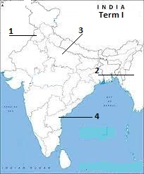
In the given outline map of India, major jute, Rubber, Coffee and Tea producing states are marked as 1,2,3 and 4.
Identify it from the following options in correct sequence.

MAP QUESTIONS FOR PRACTICE FROM AGRICULTURE – CHAPTER 4
OPTIONS:
A. West Bengal, Karnataka, Kerala, Assam
B. West Bengal, Tamil Nadu, Karnataka, Assam
C. West Bengal, Kerala, Karnataka, Darjeeling
D. West Bengal, Kerala, Karnataka, Assam
Class 10 Term 1 Map MCQ’s: Check Important Map Questions to Prepare for the Exam.
Conclusion:
This tear 2021, In CBSE class 10 term I Map MCQ’s, carry 2 marks and will be compulsory. Therefore, students should prepare for these questions carefully. Moreover, these are the easiest questions and one must score full marks in it. All students should practice locating different places on the political map of India. The map questions in CBSE class 10 term I Map MCQ’s paper is to test student’s ability. All questions will be MCQ based. Revise properly and score well in your CBSE class 10 term I Map MCQ’s.
For MCQ’s from Resources and Development and for Class X Term 1 Agriculture MCQ’s As Per New Rationalized Syllabus 2021, click here.
You may be interested in:
POTENTIAL, DEVELOPED, STOCK AND RESERVE WITH EXAMPLES
100 Geography Questions For NTSE 2022 Which Can Create Difference – I
60 Most Expected Geography Questions In Term I From Class X


0 Comments