60 Geographical Terms Commonly Used In Social Science:
While studying Social Science you will come across many Geographical terms. You are also familiar with these 60 Geographical terms but never tried to understand. For example Bay and Gulf, Lake and Lagoon, Delta and estuary are some of the Geographical terms which are very commonly used but creates confusion.
Today in this article I am going to explain few Geographical terms with pictures for elementary students. These 60 Geographical terms will definitely enhance your knowledge. It will also help you for different competitive exams. Let’s take a look at 60 Geographical terms that are most commonly used .
60 Geographical Terms
Archipelago and Cordillera
Archipelago: A place where there are many islands in a group. In other words chain of islands. For example Andaman and Nicobar islands is an archipelago. It has more than 550 islands.
Cordillera: A long chain of mountains.
Mountain and Range
Mountain: A long and high land which is pointed at the top. For example Himalaya हिमालय-भारत का सबसे कमज़ोर पर्वत is a mountain with Mt. Everest, Kanchenjunga, Nanda Devi as Himalayan peaks.
Range: Range is a series of mountains. For example Himalaya is a mountain which has many ranges like Himadri, Himachal and Shiwalik.
Antipodes: Two points that are exactly on the opposite sides of the earth. Foe example the North Pole and the South Pole.
Basin: The area of land through which a river flows, making it to be lower than the surrounding land. For example Ganga basin, Chambal basin, Mahanadi basin etc.
Delta and Estuary
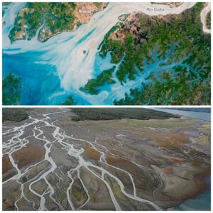
Estuary and Delta
Delta: A triangular piece of fertile land formed by a river before falling into the sea. It is formed only when the river is dead slow. World’s largest delta is the Sunderban delta formed by river Ganga and Brahmaputra.
Estuary: An area where the fresh water from a river meets the sea or ocean at comparatively high speed. It is funnel shaped. Towards the sea it is wide open. In India both Narmada and Tapi rivers form an estuary before falling into the Arabian sea. DELTA AND ESTUARY.
Moreover, an estuary is just the opposite of delta.
Bay and Gulf
Bay: A small body of water which is wide open from one side and enclosed partially by land. For example, Bay of Bengal in India and Hudson Bay in Canada.
Gulf: A gulf is a place where the sea enters deep into the land. They are enclosed by land from three sides. For example Gulf of Kutchch and Gulf of Cambay in Gujarat.
60 Geographical Terms For Students
Strait and Isthmus
Strait: A narrow passage of water connecting two other two large water bodies. For example India and Sri Lanka are separated by a narrow water body which connects Bay of Bengal and Indian Ocean. Name of the strait is Palk Strait.
Isthmus: A narrow strip of land that connects two big landmasses and also separates two water bodies. The best example of an Isthmus is Panama Isthmus which connects North America with South America. Also separates Pacific ocean with Atlantic ocean.
Sea and Ocean
Sea: A huge low lying area filled with salty water. Example Arabian sea, Caspian sea, Mediterranean sea.
Ocean: When two or more sea meet they form an ocean. It is generally a very large salt water body. Bay of Bengal sea and Arabian sea meet to form Indian ocean.
Lake, Lagoon and Oasis
Lake: A lake is usually a depression or a low area which is filled with water. It can be a salt water lake like sambhar lake in Rajasthan. It can be a fresh water lake also like lake Superior. Most of the lakes contain saline water.
Lagoon: Lagoon is defined as backwater of sea. It is a shallow water body separated by a sand bar but connected with sea. Clilika lake is the world’s largest lagoon.
Oasis: A watery area in desert or a a desert that has water and vegetation. Example Siwa Oasis in Egypt.
Peninsula and Island
Peninsula: A triangular piece of land surrounded by water from three sides is called a Peninsula. India and Saudi Arabia are peninsulas.
Island: An Island is a piece of land surrounded by water from all sides. Example Lakshadweep, Sri Lanka, Andaman & Nicobarअंडमान और निकोबार द्वीप समूह
Plateau and Hill
Plateau: A high land which is flat from the top is called as plateau. For example the Deccan plateau, Chhota Nagpur plateau etc.
Hill: A raised land which is not very high is called a hill. Deccan plateau has many hills like Annamalai, Nilgiri, Cardamom hills etc.
Canal and Channel
Canal: A manmade waterway created by diverting the flow of a river is called a Canal generally for irrigation or easier transportation. For example Suez canal, Indira Gandhi canal etc.
Channel: A narrow stretch of water between two large water bodies is called a Channel. For example English Channel.
Gorge and Canyon
Gorge: It is a French word which means throat or neck. A Gorge is a narrow valley with steep rocky walls created by a river between hills or mountains.
Canyon: A canyon is a deep narrow valley with steep sides created by the river due to weathering or erosion. For example Grand Canyon in U.S.A. formed by Colorado river.
Tributary and Distributary
Tributary: When a small river joins a big river, it is called a tributary. Yamuna, son, Chambal, Gandak, Kosi are all tributaries of river Ganga.
Dis-tributary: When a river gets distributed into many different channels before falling into the sea, are called dis-tributaries. For example Hugli river is a distributary (branch) of river Ganga.
Cape and Cave
Cape: A cape is a high or land point of land that narrowly extends into a water body. For example Cape Comorin in Tamil Nadu is the last point of India’s mainland. Similarly, Africa’s last point is Cape of Good Hope.
Caves: Caves are generally a large hollow in the ground or in the mountains formed by the weathering. They are large enough for a human to enter.
Stalactite and Stalagmite:
Stalactite: It is an “I” shaped formation that hangs from the roof of a cave and is produced by mineral (limestone) mixed water dripping from the ceiling (roof) of cave.
Stalagmite: It is also formed by the mineral mixed water dripping on the floor. It rises from the floor.
Magma and Lava:
Magma: Molten rock inside the earth if called Magma.
Lava: When molten rocks come out on to the earth’s surface, it is called Lava “हमारी पृथ्वी के अंदर” .
Igneous, Sedimentary and Metamorphic rocks:
Igneous rocks: Rocks which are formed by the cooling of lava are called Igneous rocks. They are also known as primary rocks. These rocks are made from fine grains and are usually very hard. Example is Basalt.
Sedimentary rocks: Rocks formed by the deposition of sediments are called Sedimentary rocks. These rocks are soft and many different colour of layers are visible. Himalayas are made up of Sedimentary rocks. Example is sandstone.
Metamorphic rocks: when Igneous and Sedimentary rocks go under the earth because of earthquake or volcano, their original form changes due to high temperature and pressure. Thus, get converted into Metamorphic rocks. For example Limestone under high temperature and pressure changes into marble INSIDE OUR EARTH .
Tropic of Cancer and Tropic of Capricorn:
Tropic of Cancer is the latitude which makes an angle of 23 and 1/2 degrees North from the center of the earth. It divides India into almost two equal parts. On 21st of June, sunrays falls directly on this latitude all over in the Northern Hemisphere.
Tropic of Capricorn is the latitude which makes an angle of 23 and 1/2 degrees South from the center of the earth. Therefore, on 21st of December, sunrays falls directly on this latitude all over in the Southern Hemisphere. Do you know that Australians celebrate Christmas during summer season.
Arctic Circle and Antarctic Circle:
Arctic Circle is the latitude which makes an angle of 66 and 1/2 degrees North from the center of the earth. It lies in the Northern Hemisphere.
Antarctic Circle is the latitude which makes an angle of 66 and 1/2 degrees South from the center of the earth. It lies in the southern hemisphere What are lines of latitudes and longitudes on Globe? .
Northern Hemisphere and Southern Hemisphere
Northern Hemisphere is the part of the earth which lies above the equator. It stretches from 0 degree equator to 90 degree North Pole.
Southern Hemisphere is the part of the earth that lies below the equator. It stretches from 0 degree equator to 90 degree South Pole.
Do you know why International Date Line is not straight?
Dark Continent and White continent
Dark Continent: Africa is known as the Dark Continent not because of black skin people or dense forests but because it was the last continent to be discovered. A rich continent in terms of mineral resources remained unexplored for long.
White Continent: Antarctica is a continent which remains covered with snow. Therefore, it is referred to as White Continent.
Waves and Tides:
Waves are the rising and falling of water in the sea. It is caused by wind. The strength of wave is determined by the speed of wind. However, during a full moon day, the waves rise very high in the sea.
Tides are caused by the gravitational pull of earth and sun. During high tide, the sea water expands. During low tide, sea water recedes back.
Rotation and Revolution:
Rotation is the spinning of earth on it’s own axis. Earth takes 24 hours to complete one full rotation. It causes day and night on earth.
Revolution is moving of earth around the sun. Earth takes 365 days and 6 hours to complete one revolution. It causes change in seasons.
Sea cliff and sea arches:
A steep coastal slope created by the erosive power of sea waves is called sea cliff.
Sea arches are created by nature. Soft rocks get eroded over millions of years as waves hit, carving caves and tunnels in the rock.
Sea beach and sea coast:
Vast stretch of sandy land formed naturally over millions of years wherein particles of sand brought in by the sea were deposited along the side of the sea. Thus, forming a beach. Moreover, people enjoy at sea beach.
Sea coast is the part of the land adjoining or near the sea.
Glacier and Iceberg:
The mountain of snow is called Glacier. It is formed due to continuous accumulation of snow. When it becomes too heavy, it starts moving under its own weight. Mainly found over high mountains. Gangotri is a glacier from where Ganga river originates.
A large piece of freshwater ice that has broken off a glacier and is floating freely in sea water. Moreover, It is dangerous because only 10 percent of it is visible and 90 percent of it remains under water.
Isobars and Isotherms:
A line drawn on the map joining places of equal atmospheric pressure. An Isobar marked 1004 millibars represents high pressure while 976 millibars represents an area of low pressure.
A line drawn on the map or a chart showing places of equal temperature is known as Isotherms.
Atmosphere and Environment:
Atmosphere is the blanket of air surrounding the earth. It has layers of different gases which filters the harmful rays of the sun
Environment is things present in our surroundings. Moreover, it includes plants, animals, micro-organisms and even non-living things NCERT NOTES OF CLASS 7 GEOGRAPHY CHAPTER 1 ENVIRONMENT..
Planet and star:
A heavenly body which moves in an elliptical path round a star (sun). There are total nine planets in our solar system. Moreover, Earth is also a planet which revolves around sun. Pluto is no more considered as a planet. However, it was considered as a planet for more than 76 years.
Star is also huge glowing balls of gases. Stars have their own heat and light. The closest star from the earth is the Sun.
Meteors, Meteoroids and Asteroids:
Meteors are usually a small object which enters earth’s atmosphere at very high speed. When it enters the earth’s atmosphere, it burns due to friction. Moreover, It appears like a broken star.
Meteoroids are pieces of iron or rock that orbit the sun, just as planets.
Many small objects made of rocks revolve around the Sun. They are usually found between Mars and Jupiter in our Solar System. The biggest asteroids can be hundreds of kilometers in diameter.
Satellite and Comet:
Satellite is an object that moves around the planet. However, It can be both, man-made and natural. Moon is a natural satellite of earth whereas, PSLV, INSAT, ARYABHATT are all man-made satellites.
Comets are snowballs of frozen gases, rock and dust that orbit the Sun. Example of a comet is Halley’s comet. It can be seen from the earth in every 75 years. Moreover, fortunate people have seen in 1986 and now will return back in 2061 What is solar system?.
Conclusion:
Hope these 60 Geographical terms will help you in your studies, project and competitive exams geography-gk-questions-with-answers . If you want to know about more Geographical terms, you may write in the comment box.
You may like to read:
Integrating Chhattisgarh with Gujarat – Complete Guidance
Integrating Bihar with Tripura and Mizoram Under Ek Bharat Shreshtha Bharat
NEW EIGHTH CONTINENT – ZEALANDIA


0 Comments