Class VI Geography Chapter 4 Lesson Plan
Geography Chapter 4 Lesson Plan With Engaging Classroom Exercises
Topics covered: Geography Chapter 4 Maps
General Objective:
Firstly, to develop an interest in the subject.
Secondly, to apply the knowledge practically in real life.
Finally, developing scientific temperament among the students.
Specific Objective:
- Students will acquire knowledge about the different type of maps.
- They will learn to define maps and its types.
- To enable the students to explain scale, cardinal points and symbols.
Checking Previous Knowledge:
At first, the teacher checks the previous knowledge of the students by asking a question.
Teacher: Have you ever seen the map of India?
Students’ response: Yes
Teacher: What do you see in the map of India?
Students’ response: states, Capitals, towns, and cities.
Teacher: O.K.
Introducing Topic:
Now, the teacher introduces the topic by asking basic questions like:
Teacher: Have you ever seen the world map?
Student’s response: Yes teacher.
Teacher: Have you seen the map of your state?
Student’s response: Yes teacher/ No teacher. (mixed answer)
Teacher: Can you see mountains, Plateaus, rivers and deserts in the map?
Student’s answer: Yes teacher/ No teacher. (mixed answer)
Teacher: What is the map called which shows mountains, Plateaus, rivers and deserts?
Now, the students are unable to answer this question.
Statement of Topic
So, the teacher will announce the topic.
Today we are going to study about maps and its types.
Teaching Method:
Story telling
Geography Chapter 4 Lesson Plan With Engaging Classroom Exercises
Teaching aids:
Text Book, Black Board, smart board, Globe
Technique:
Interactive with common examples.
First, the teacher narrates a story.
What is a map?
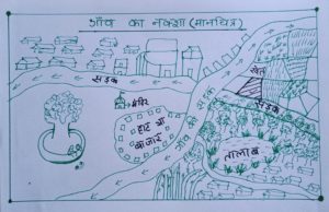
MAP OF A VILLAGE
Suppose there are many farms in your village.
One of these farms is yours that you have bought.
How would you tell your friend in your school which of the many farms you have bought?
Can you pick up your farm and take it to your class?
No.
But you can easily tell him with the help of a paper pen a picture of the farm you bought.
This is called a map.
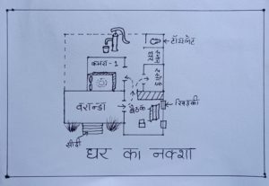
Map of a house
MAP OF A HOUSE
What is the map of the house like?
As is the house, so is the map of the house.
The picture given above will give an understanding of what the house map is like.
First of all, we get a veranda as soon as we climb two or four steps.
On one of the walls of the veranda, there is a door through which we enter the first room.
This room has windows on two walls but there is another door to go inside the house.
Similarly, as soon as we leave the door, we see another room on the left.
If you leave this room, you get the cooking room in front which is called the kitchen.
In the same way, leaving the kitchen and going forward, then the bathroom (BATHROOM).
And on going beyond that, you get a toilet.
If you make this on paper, then the map of the house will be made.
Similarly, a house is formed by combining many rooms.
Map of India:
Just as you belong to a state, in the same way the state also belongs to a country.
There are many states in India.
Like Jammu and Kashmir, West Bengal, Assam, Gujarat, Rajasthan, Tamil Nadu……..
With the map of India, you can understand how many states are there in India and which state is located where.
In this you may not see your district or village because India is a vast country.
What is the type of map?
When you see the map of India, you see the names of the states on it.
But you must be thinking that the Himalayas, plateaus, and deserts are nowhere to be seen in this.
So there are many types of maps.
Geography Chapter 4 Lesson Plan With Engaging Classroom Exercises
Types of Maps
Here we will talk about only two types of maps: the political map of India and the physical map of India.
I) Political Map of India (Map) :
In the political map of India, you will see only the state, its boundaries, capital, and major cities.
It is written on the top of the map whether it is a political map or a physical one.
In any atlas, you can see the size and position of India.
Two islands of India will also be visible in the political map – Lakshadweep and Andaman and Nicobar.
II) Physical Map of India :
Similarly physical is written on the map.
In that, you will not see the names of states, names of cities, names of districts.
In this, you will see only mountains, plateaus, plains, rivers, and deserts.
Where there is very high land, we call it a mountain like the Himalayas.
The land will be less high than that and will be flat on top, we will call it a plateau.
Where sand is found in abundance, we will call it a desert.
Where the land is just as flat as the plain, we will call it the plain.
From this map, we get to know where mountains, plateaus, deserts, rivers, and seas are located in India.
However, the teacher uses various methods to make the topic interesting by interacting with the children in the class.
Thereafter, by asking very simple questions, the teacher draws the attention of the class.
But, also make sure that the children are involved in the discussion.
Therefore, While interacting with the students, the teacher also tells about the cardinal points and scale.
Geography Chapter 4 Lesson Plan With Engaging Classroom Exercises
Content/ Teaching Points:
- Introduction
- Difference between map and globe
- Physical, Political, Thematic maps
- Components of maps: Distance, direction, symbols
- Sketch
- Plan
Teaching Method:
Activity 1: How to find and mark the states of India on the map.
Aim: To mark the given states on the map of India.
Time: 20 minutes
Materials required: Atlas and an outline political map of India.
Procedure: The teacher divides the class into 5 groups.
Each group will be given the names of five different states of India.
Students have to find and identify the states and label them in bold letters along with their capital.
Challenging Question: Name the neighboring countries that touch the borders of India.
Skills Developed: Observation and thinking and collaborative skills
Assessment: It will be a classroom activity that will not be assessed.
Activity II
Aim: To understand what are cardinal points (directions and sub-directions)
Time: 30 minutes
Materials required: Chalk, Board, and Pol. Map of India
Procedure:
The teacher first draws the four directions and sub-directions on the board and hangs a big map of India.
Divides the class into 4 groups.
Each group will be asked 4 questions.
One member of the group will have to give the answer within 1 minute.
Sample questions:
- Suppose you are going to Delhi from Kolkata, you will travel in which direction.
2. Now, you have to return back to Kolkata from Delhi, you will travel in which direction.
Challenging Question: If you have to travel from Kerala to Lakshadweep, you will travel in which direction.
Skills Developed: Observation and thinking, collaborative, and competitive skills.
Assessment: It will be an indoor activity.
i) For each correct answer, the teacher will award 5 points to the group.
NOTE: Marks will be awarded to different groups according to their performance.
Assessment Criteria:
Indicators
- Relevance of Content
- Understanding
- Awareness of the information gathered
- Creativeness
Classwork:
i) Objective and short answer-type questions will be done.
ii) Teacher will also discuss Long answer-type questions in the class.
Homework:
Draw the plan and sketch of the house in which you live.
Multidisciplinary Integrated learning:
- Hindi and English: Maps tell the story about a place. Write an essay.
- Art: Locating a place on the map with the help of latitudes and longitudes.
- English: Debate on the topic ” Maps are better than Globe”.
- Maths: Calculate the time difference between two different places on the map.
Learn How to calculate time using longitudes explained Step by step
Learning Outcome:
After the completion of this chapter, students will be able to
Firstly, Exhibit a clear understanding of various types of maps.
Secondly, will be able to differentiate between Physical and Political maps.
get familiarized with terms like cardinal symbols.
Finally, develop a clear understanding of directions on maps.
Remedial Measure:
Each One – Teach One.
Children sitting on the left side of the row will explain the chapter to the children sitting on their right.
Interesting and picture-based Chapter 3 Motions Of The Earth – Worksheet can be downloaded from here.
Geography Chapter 4 Lesson Plan With Engaging Classroom Exercises
Conclusion:
The purpose of writing class VI Geography Chapter 4 Lesson Plan is to make the topic easy and understandable. Class VI Geography Chapter 4 Lesson Plan will keep the students engaged in classroom activities. It will also help the teachers to plan and execute the chapter in a better way.
I hope, this Class VI Geography Chapter 4 Lesson Plan will definitely help you in connecting with your students.
Class VI History Chapter 3 Lesson Plan – In the Earliest Cities
Class VI Civics Chapter 3 Lesson Plan: What is Government
Was this lesson plan helpful to you? Write your views in the comment box.


0 Comments