Locating Places on the Earth Lesson Plan with Activities
Locating Places on the Earth Lesson Plan with Activities is essential for helping young learners. Children will understand the geographical concepts of latitude, longitude, and the Earth’s grid system engagingly. Moreover, this chapter lays the foundation for map reading and global awareness. Therefore, this lesson plan on Locating Places on the Earth goes beyond textbook learning. The lesson plan will help the teacher in incorporating interactive tools like globes, maps, and coordinate-based games. Teachers can spark curiosity and make abstract concepts more tangible. This is a well-structured Lesson Plan with Activities. It will encourage students to think critically, ask questions, and apply their knowledge through hands-on experiences.
This approach will not only improve retention but also build essential skills in spatial thinking. Whether in a traditional classroom or a digital setup, this Locating Places on the Earth lesson plan will transform geography into an exciting journey of discovery.
Here’s a detailed lesson plan for Class VI Geography – Chapter 1: “Locating Places on the Earth”. The lesson plan follows a structured format that school teachers or trainees can use. So, let’s begin.
Locating Places on the Earth Lesson Plan with Activities
Chapter 1: Locating Places on the Earth

Locating Places on The Earth
1. General Information
Subject: Geography
Class: VI
Chapter: Locating Places on the Earth
Duration: 40–45 minutes
Textbook: NCERT Geography – The Earth: Our Habitat
2. Learning Objectives
After the completion of the chapter, students will be able to:
- Understand the concept and significance of latitudes and longitudes.
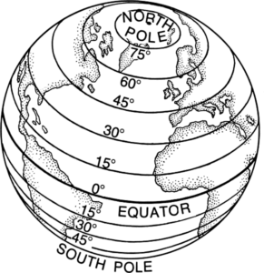
Identify the Equator, Prime Meridian, Tropic of Cancer, The Tropic of Capricorn, the Arctic and Antarctic Circles.
Explain how to locate places on Earth using a grid system.
Use a globe or a map to locate any place using coordinates.
3. Teaching Aids / Resources
Globe
Map of the World
Flashcards with the names of countries and coordinates
PowerPoint Presentation (if digital facilities are available)
Worksheet for practice
4. Previous Knowledge
The teacher expects the Students to have a basic understanding of:
The shape of the Earth.
Directions (North, South, East, West).
The concept of a globe or a map.
5. Teaching Methodology
Introductory Approach:
Initially, the teacher will use this method to introduce the topic by connecting it with real-life examples.
The teacher will begin the class by asking students how they find places using Google Maps or how travelers navigate the world.
This approach will create interest and prepare students for the new concept.
Demonstration Method:
The teacher also uses the demonstration method to explain the chapter.
He / She will use visual aids like a globe, world map, or charts to demonstrate concepts such as latitudes, longitudes, the Equator, and the Prime Meridian.
This method will help students understand abstract ideas more concretely and visually.
Interactive Discussion:
The teacher encourages students to participate in discussions.
Students will be asked Open-ended questions.
It will be prompting them to share their observations.
This method will help develop critical thinking and allow students to learn from each other’s ideas.
Questioning Technique:
The teacher also uses this technique to ask questions before, during, and after the lesson.
This will help assess understanding, provoke curiosity, and maintain student engagement.
Moreover, it will also help reinforce key points of the lesson.
Activity-Based Learning:
Activity-based learning will help the students engage in hands-on activities.
These activities include locating places on a map using coordinates, drawing latitudes and longitudes, or solving map-based worksheets.
The activities will make the learning fun, interactive, and effective in reinforcing the lesson.
Locating Places on the Earth Lesson Plan with Activities
6. Introduction (5 minutes)
Begin with a question: “How do pilots or sailors know where they are on Earth?”
Show a globe and ask: “Have you seen this before? What does it represent?”
Relate to real-life examples like Google Maps, GPS.
7. Presentation / Explanation (25 minutes)
| Topic | Teacher’s Activity | Student’s Activity |
|---|---|---|
| Globe & Axis | Show the globe, explain the Earth’s shape and axis. | Observe and ask questions. |
| Latitudes | Draw latitudes on the board, explain the Equator, Tropics, Arctic/Antarctic Circles. Show on the globe. | Take notes, locate latitudes on the globe. |
| Longitudes | Draw longitudes, explain the Prime Meridian, and how time zones work. | Understand and ask questions. |
| Grid System | Demonstrate how latitude & longitude form a grid. Use examples like “0°N, 0°E”. | Try locating a point on the map/globe using coordinates. |
| Activity | Give students coordinates and let them find locations on the globe or a map. | Participate in the activity. |
Locating Places on the Earth Lesson Plan with Activities
8. Activity 1: “Find the Location – Coordinate Challenge”
Objective:
To help students learn how to locate places on the globe or a map using latitude and longitude.
Materials Needed:
World map or globes
Flashcards with coordinates (e.g., 51°N, 0°W)
Markers or pins
Worksheet to record answers
Steps:
Introduction: Begin by revising what latitude and longitude are, and how coordinates help in locating a place.
Group Division: Divide the class into small groups of 3–4 students.
Distribute Flashcards: Give each group a set of flashcards with coordinates written on them.
Locate Places: Ask each group to find the location on the globe or map that matches the given coordinates.
Mark and Record: Students will mark the spot with a pin or sticker and write the name of the country or city on their worksheet.
Review: Go over the answers as a class and discuss any challenges they faced.
Activity 2: “Create Your Grid Map”
Objective:
To understand the grid system and practice plotting coordinates.
Materials Needed:
Blank A4 sheets or graph paper
Rulers, pencils, markers
List of coordinates with place names (prepared by the teacher)
Steps:
Introduction: Briefly explain the Earth’s grid system using a board or chart.
Grid Drawing: Ask students to draw a simple grid on paper (horizontal lines for latitudes and vertical lines for longitudes).
Plot Points: Give students a list of 5–6 coordinates. They will plot these points on their grid and label them with the corresponding place names.
Creative Addition (Optional): Students can color and decorate their maps, adding oceans, continents, or landmarks.
Presentation: Invite a few students to explain one or two locations they plotted and how they found them.
9. Evaluation / Assessment (5 minutes)
Oral / Written Questions:
Define latitude and longitude.
What is the total number of longitudes and latitudes?
Where is the Tropic of Cancer located?
Why is the Prime Meridian important?
10. Recapitulation (5 minutes)
In recapitulation, the teacher will ask quick questions like:
What is the importance of the Equator?
What is the Prime Meridian?
How do we locate a place using latitude and longitude?
11. Homework
Draw and label major latitudes and longitudes on a blank world map.
Write the coordinates (approx.) of your city/town.
12. Learning Outcome
Students will:
Develop map-reading and location-identifying skills.
Understand Earth’s geographical grid system.
Be able to independently use a globe or map for basic navigation.
Locating Places on the Earth Lesson Plan with Activities
13. Conclusion:
In conclusion, the lesson plan on “Locating Places on the Earth” aims to build a strong foundation in geographical skills by introducing students to the concepts of latitude, longitude, and the global grid system. By using a variety of teaching methodologies such as demonstration, interactive discussion, questioning, and activity-based learning, the lesson ensures that students remain actively engaged and can relate the topic to real-life situations. The use of globes, maps, and hands-on activities makes abstract ideas more understandable and enjoyable. Through this lesson, students not only learn how to locate places on Earth but also develop critical thinking and spatial awareness. The activities provided reinforce the learning outcomes and allow students to apply their knowledge practically.
Overall, this lesson plan encourages curiosity about the world and helps students become confident in reading maps and understanding Earth’s geography. It sets the stage for more advanced topics in geography in future classes.


0 Comments