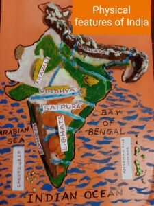
Class IX Geography chapter 2 Physical features of India has a total of 50 questions divided into three sets. These questions will help you to prepare for your CBSE exams. Also helpful to those who are preparing for competitive exams like NTSE, CTET, TET, NDA etc. Pl. note that all questions are from class IX Geography chapter 2 Physical features of India. For notes and question answers from chapter 1 click on the given link INDIA – SIZE AND LOCATION
Class IX Geography chapter 2 Physical features of India

class IX Geography chapter 2
SET- A
Q 1. Which among the following is not a physical feature of India?
A. COASTAL PLAINS
B. TECTONIC PLATES
C. PLATEAUS
D. ISLANDS.
Q 2. When two plates come towards each other, it is called____________?
A. Convergence
B. Divergence
C. Transform boundary
D. Theory of Plate Tectonics.
Q 3. Which is the highest range of Himalayas?
A. Mt. Everest.
B. Himachal
C. Shiwalik
D. Himadri.
Q 4. Himalayas in North-East are popularly known as
A. Arunachal
B. Nepal Himalayas
C. Purvanchal
D. Kumaon Himalayas
Q 5. Which Physiographic division of India is the most densely populated.
A. The Northern Plains.
B. The Peninsular Plateau
C. The Coastal Plains.
D. The Northern Mountains.
Q 6. The highest peak of Western ghat is
A. Anai Mudi
B. Doda-Beta
C. Annamalai Hills.
D. Mahendra Giri.
Q 7. Thar desert lies to the __________margins of the Aravali hills.
A. Eastern
B. Western
C. Northern
D. Southern.
Q 8. By what name is the Northern part of the Western coastal Plains Known ?
A. Malabar coast
B. Coro Mandal coast
C. Konkan Coast.
D. Northern Circars.
Q 9. Which is the largest salt water lake in India?
A. Dal Lake
B. Mansarovar Lake
C. Sambhar Lake
D. Chilika Lake
Q 10. Name the island group of India having coral origin.
A. Andaman Islands.
B. NIcobar Islands.
C. Barren Islands.
D. Lakshadweep Islands.
Class IX Geography chapter 2 Physical features of India
SET- B
Q1. Which stone is used in making Talcum Powder?
A. Soap stone
B. White Marble
C. Granite
D. Limestone
Q 2. Identify the country/continent which was not the part of Gondwanaland.
A. South Africa.
B. South America.
C. Europe.
D. Australia.
Q3. What is the part of Himalayas lying between Tista and Dihang river called?
A. Punjab Himalayas
B. Kumaon Himalayas
C. Nepal Himalayas
D. Assam Himalayas
Q4. By what name are the longitudinal valleys between Himachal and Shiwalik ranges are known.
A. Duns
B. Pir Panjal
C. Kangra valley
D. Kullu valley.
Q5. Which hill is not the part of Purvanchal?
A. Patkai hills
B. Naga hills.
C. Shevroy hills
D. Mizo hills.
Q6. What do you mean by the term “Doab”?
A. Land between two mountain ranges.
B. Land between two rivers.
C. Land between two plateaus.
D. Crescent shaped dunes.
Q7. What are the two types of Alluvial soil?
A. Khadar and Bhabar
B. Bhabar and Bangar
C. Khadar and Bangar
D. Bangar and Kanker.
Q8. Name the Indian state where Kanchenjunga is located? हिमालय-भारत का सबसे कमज़ोर पर्वत
A. Jammu and Kashmir.
B. Himachal Pradesh.
C. West Bengal.
D. Sikkim.
Q9. Which is the largest riverine island in the world?
A. Tarai
B. Majuli
C. Sunderbans
D. Vindhya.
Q10. What is the name given to the southern part of the Eastern coastal plains?
A. Konkan
B. Kannad
C. Coromandal
D. Malabar.
Internal questions from Physical features of India chapter 2
Q11. What are “Barchans”?
A. Fertile land in Desert.
B. Oasis
C. Small river in desert.
D. Crescent shaped dunes.
Q12. By which name Lakshadweep islands were not known?
A. Pitti island
B. Laccadive
C. Minicoy
D. Amindive
Q13. Which is a good example of the first kind of coral reefs?
A. Atolls.
B. Fringing reef
C. Great Barrier reef.
D. Coral Polyps.
Q14. In which year the south west island group of India was named Lakshadweep.
A. 1971
B. 1973
C. 1975
D 1977.
Q15. Name an island which is inhabited and has a famous Bird Sanctuary.
A. Pitti island.
B. Barren island
C. Andaman Island
D. Nicobar island.
Class IX Geography chapter 2 Physical features of India
Learn to make Physical features (map) of India at home using wheat flour (Dough)
SET – C
Q1. In the following questions a statement of Assertion (A) is followed by a statement of Reason (R).
Identify and mark the correct choice.
ASSERTION (A): The colour of soil varies from one place to another.
REASON (R): Soil is formed out of different types of rocks.
(A) Both A and R are true and R is the correct explanation of A.
(B) Both A and R are true and R is not the correct explanation of A.
(C) A is true but B is false.
(D) Both A and R are false.
Q2. Two plates move horizontally past each other.
They form___________ boundary.
A. Convergent boundary
B. Divergent boundary
C. Transform boundary
D. Destructive plate boundary.
Q3. Most volcanoes and earthquakes in the world are located at ______________margins.
A. Plate margins.
B. Oceanic plates.
C. Continental plates.
D. Between the minor plates.
Q4. Angara land and Gondwanaland were the parts of which super continent?
A. Eurasia
B. Pangea
C. Indo-Australia
D. North American continent.
Q5. Which is the most ancient land masses on the earth’s surface?
A. The Northern Mountains.
B. The Northern Plains
C. The Peninsular Plateau
D. The Great Indian Desert.
Application based questions
Q6. Which is the most continuous range of Himalayas?
A. Himadri range
B. Himachal range
C. Shiwalikk range
D. Aravali range.
Q7. Which is the most unstable range composed of unconsolidated sediments.
A. Himadri range
B. Himachal range
C. Shiwalikk range
D. Aravali range.
Q8. The world’s largest inhabited riverine island in the world is located in which river?
A. Ganga
B. Brahmaputra
C. Godawari
D. Tista
Q9. Which river is not the tributary of river Indus?
A. Jhelum
B. Yamuna
C. Satluj
D. Beas
Q10. A narrow belt of 8 to 16 km where the river streams disappear is called _______________
A. Bhabar
B. Khadar
C. Bangar
D. Tarai.
Q11. Name the type of Alluvial soil which is renewed almost every year?
A. Bhabar
B. Khadar
C. Bangar
D. Tarai.
Q12. “Anaimudi” the higheat peak of western ghats is located on which hills?
A. Annamalai hills.
B. Nilgiri hills
C. Cardomom hills
D. Shevroy hills.
Q13. “Anaimudi” the highest peak of western ghat is located in which state?
A. Karnataka
B. TamilNadu
C. Kerala
D. Andhra Pradesh
Q14. Which one of the following ranges is not the part of Central highlands.
A. Malwa plateau
B. Chota Nagpur plateau
C. Vindhya range
D. Nilgiri hills.
Q15. Name the coastal plains which lies between Konkan and Malabar coast?
A. Kannad coast
B. Coromandal coast
C. Northern Circars
D. None of these.
Higher-order thinking skill (HOTS) questions
Q16. Identify the two hills of the Eastern ghat.
A. Vindhya and Satpura
B. Bundelkhand and Baghelkhand
C. Shevroy and Javadi
D. Annamalai and Nilgiri.
Q17. “Luni” the only large river in the desert region falls in which sea?
A. Bay of Bengal.
B. Arabian sea
C. Indian Ocean
D. It doesn’t reach up to the sea.
Q18. Where can you see a group of Barchans.
A. Jaipur
B. Ajmer
C. Jaiselmer
D. Udaipur
Q19. What are corals?
A. Sea animals.
B. Microscopic organisms
C. Fishes found in shallow water.
D. Flowers found under the sea.
Q 20. Coral reefs are formed by _______________?
A. Sea shells and sand.
B. Coral secretion and their skeletons.
C. Accumulation of rock particles.
D. Combination of salt and rocks.
Q21.Identify the correct sequence of hills from west to east.
A. Chota Nagpur plateau, Garo hills, Aravali hills, Jaintia hills.
B. Garo hills, Aravali hills, Jaintia hills. Chota Nagpur plateau
C. Aravali hills, Jaintia hills, Garo hills, Chota Nagpur plateau
D. Aravali hills, Chota Nagpur plateau, Garo hills, Jaintia hills.
Q22.Identify the correct sequence of mountain ranges/hills from North to South.
A. Karakoram, Aravali hills, Vindhya range, Nilgiri hills.
B. Aravali, Nilgiri hills, Vindhya range, Karakoram,
C. Vindhya range, Karakoram, Aravali hills, Nilgiri hills
D. Nilgiri hills, Aravali hills, Vindhya range, Karakoram
Q23. Identify the range which does not belong to Purvanchal.
A. Garo hills
B. Cardomom hills
C. Mizo hills.
D. Jaintia hills.
Q24. Through which two ranges the river Narmada flows.
A. Vindhya and Shevroy hills
B. Bundelkhand and Baghelkhand
C. Annamalai and Nilgiri
D. Satpura and Vindhya.
Q25. Mizo hills were previously known as? https://pickyourtrail.com/blog/hill-stations-in-northeast-india/
A. Lushai
B. Mizo
C. Rakaposhi
D. Pat Kai Bum
Answer Key: Class IX Geography chapter 2 Physical features of India
SET A- 1. B. Tectonic plates 2. A. Convergence 3. D. Himadri. 4. C. Purvanchal 5. A. The Northern Plains. 6. A. Anai Mudi 7. B. Western 8 C. Konkan Coast. 9. D. Chilika Lake 10. D. Lakshadweep Islands.
SET B – 1. A. Soap stone 2. C. Europe. 3. D. Assam Himalayas 4. A. Duns 5. C. Shevroy hills 6. B. Land between two rivers. 7. C. Khadar and Bangar 8. D. Sikkim. 9. B. Majuli 10. C. Coromandal 11. D. Crescent shaped dunes. 12. A. Pitti island 13. C. Great Barrier reef. 14. B. 1973 15. A. Pitti island.
SET C – 1. (A) Both A and R are true and R is the correct explanation of A. 2. C. Transform boundary 3. A. Plate margins. 4. B. Pangea 5. C. The Peninsular Plateau 6. A. Himadri range 7. C. Shiwalikk range 8. B. Brahmaputra 9. B. Yamuna 10. A. Bhabar 11. B. Khadar 12. A. Annamalai hills. 13. C. Kerala 14. D. Nilgiri hills. 15. A. Kannad coast 16. C. Shevroy and Javadi 17. D. It doesn’t reach up to the sea. 18. C. Jaiselmer 19. B. Microscopic organisms 20. B. Coral secretion and their skeletons. 21. D. Aravali hills, Chota Nagpur plateau, Garo hills, Jaintia hills. 22. A. Karakoram, Aravali hills, Vindhya range, Nilgiri hills. 23. B. Cardomom hills 24. D. Satpura and Vindhya. 25. A. Lushai


0 Comments